You are here: Home > Network List > IC - New China Digital Seismograph Network Stations List
> Station WMQ Urumqi, Xinjiang Province, China > Earthquake Result Viewer
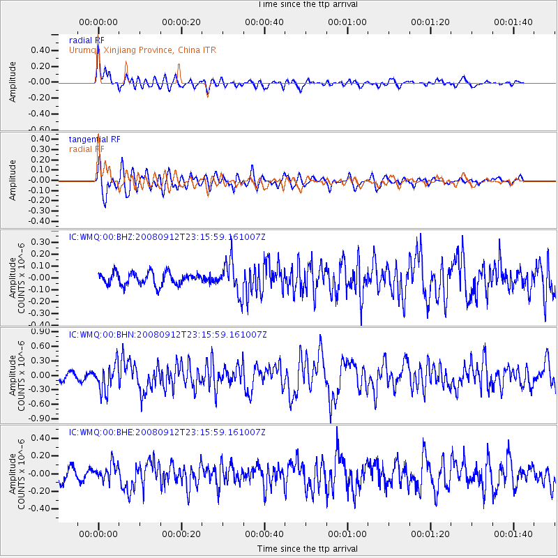
WMQ Urumqi, Xinjiang Province, China - Earthquake Result Viewer
*The percent match for this event was below the threshold and hence no stack was calculated.
| Earthquake location: |
Komandorskiye Ostrova Region |
| Earthquake latitude/longitude: |
56.3/164.1 |
| Earthquake time(UTC): |
2008/09/12 (256) 23:07:50 GMT |
| Earthquake Depth: |
9.3 km |
| Earthquake Magnitude: |
5.5 MB, 5.7 MS, 5.9 MW, 5.9 MW |
| Earthquake Catalog/Contributor: |
WHDF/NEIC |
|
| Network: |
IC New China Digital Seismograph Network |
| Station: |
WMQ Urumqi, Xinjiang Province, China |
| Lat/Lon: |
43.82 N/87.69 E |
| Elevation: |
903 m |
|
| Distance: |
48.1 deg |
| Az: |
289.068 deg |
| Baz: |
46.697 deg |
| Ray Param: |
$rayparam |
*The percent match for this event was below the threshold and hence was not used in the summary stack. |
|
| Radial Match: |
85.242615 % |
| Radial Bump: |
400 |
| Transverse Match: |
82.41199 % |
| Transverse Bump: |
400 |
| SOD ConfigId: |
2560 |
| Insert Time: |
2010-03-05 00:25:17.454 +0000 |
| GWidth: |
2.5 |
| Max Bumps: |
400 |
| Tol: |
0.001 |
|
Signal To Noise
| Channel | StoN | STA | LTA |
| IC:WMQ:00:BHN:20080912T23:15:59.161007Z | 4.03928 | 2.8531232E-7 | 7.063446E-8 |
| IC:WMQ:00:BHE:20080912T23:15:59.161007Z | 1.5944617 | 9.293641E-8 | 5.828701E-8 |
| IC:WMQ:00:BHZ:20080912T23:15:59.161007Z | 2.8139968 | 1.4517279E-7 | 5.1589538E-8 |
| Arrivals |
| Ps | |
| PpPs | |
| PsPs/PpSs | |


