You are here: Home > Network List > CI - Caltech Regional Seismic Network Stations List
> Station BAR Barrett, Tecate, CA, USA > Earthquake Result Viewer
BAR Barrett, Tecate, CA, USA - Earthquake Result Viewer
| Earthquake location: |
Near Coast Of Peru |
| Earthquake latitude/longitude: |
-13.4/-76.6 |
| Earthquake time(UTC): |
2007/08/15 (227) 23:40:57 GMT |
| Earthquake Depth: |
39 km |
| Earthquake Magnitude: |
6.7 MB, 7.9 MS, 8.0 MW, 7.5 ME |
| Earthquake Catalog/Contributor: |
WHDF/NEIC |
|
| Network: |
CI Caltech Regional Seismic Network |
| Station: |
BAR Barrett, Tecate, CA, USA |
| Lat/Lon: |
32.68 N/116.67 W |
| Elevation: |
521 m |
|
| Distance: |
59.7 deg |
| Az: |
321.044 deg |
| Baz: |
133.487 deg |
| Ray Param: |
0.06193721 |
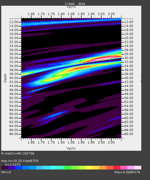
| Estimated Moho Depth: |
30.25 km |
| Estimated Crust Vp/Vs: |
2.01 |
| Assumed Crust Vp: |
6.264 km/s |
| Estimated Crust Vs: |
3.12 km/s |
| Estimated Crust Poisson's Ratio: |
0.33 |
|
| Radial Match: |
98.180786 % |
| Radial Bump: |
198 |
| Transverse Match: |
93.14424 % |
| Transverse Bump: |
400 |
| SOD ConfigId: |
2564 |
| Insert Time: |
2010-02-26 00:09:40.952 +0000 |
| GWidth: |
2.5 |
| Max Bumps: |
400 |
| Tol: |
0.001 |
|
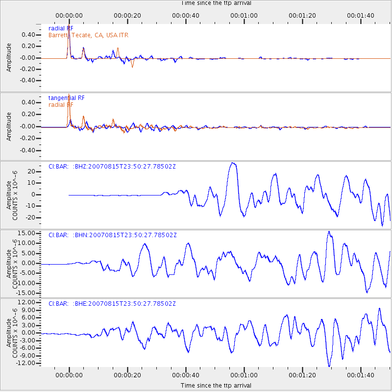
Signal To Noise
| Channel | StoN | STA | LTA |
| CI:BAR: :BHN:20070815T23:50:27.78502Z | 3.9684155 | 5.053307E-7 | 1.2733815E-7 |
| CI:BAR: :BHE:20070815T23:50:27.78502Z | 3.8844926 | 3.4594885E-7 | 8.905896E-8 |
| CI:BAR: :BHZ:20070815T23:50:27.78502Z | 11.024542 | 1.4296866E-6 | 1.2968216E-7 |
| Arrivals |
| Ps | 5.1 SECOND |
| PpPs | 14 SECOND |
| PsPs/PpSs | 19 SECOND |


