You are here: Home > Network List > IC - New China Digital Seismograph Network Stations List
> Station WMQ Urumqi, Xinjiang Province, China > Earthquake Result Viewer
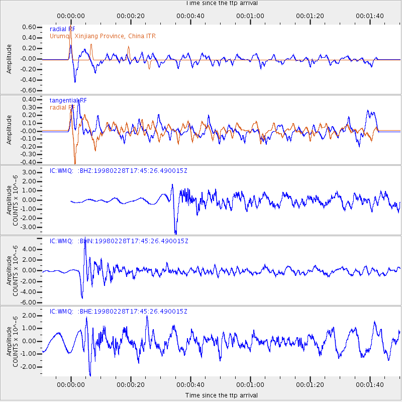
WMQ Urumqi, Xinjiang Province, China - Earthquake Result Viewer
*The percent match for this event was below the threshold and hence no stack was calculated.
| Earthquake location: |
Southeast Of Honshu, Japan |
| Earthquake latitude/longitude: |
33.5/138.1 |
| Earthquake time(UTC): |
1998/02/28 (059) 17:38:48 GMT |
| Earthquake Depth: |
291 km |
| Earthquake Magnitude: |
5.7 UNKNOWN, 5.3 MB, 5.7 MW |
| Earthquake Catalog/Contributor: |
WHDF/NEIC |
|
| Network: |
IC New China Digital Seismograph Network |
| Station: |
WMQ Urumqi, Xinjiang Province, China |
| Lat/Lon: |
43.82 N/87.69 E |
| Elevation: |
903 m |
|
| Distance: |
40.2 deg |
| Az: |
300.127 deg |
| Baz: |
87.357 deg |
| Ray Param: |
$rayparam |
*The percent match for this event was below the threshold and hence was not used in the summary stack. |
|
| Radial Match: |
64.61363 % |
| Radial Bump: |
400 |
| Transverse Match: |
62.397156 % |
| Transverse Bump: |
400 |
| SOD ConfigId: |
4480 |
| Insert Time: |
2010-03-05 00:25:28.696 +0000 |
| GWidth: |
2.5 |
| Max Bumps: |
400 |
| Tol: |
0.001 |
|
Signal To Noise
| Channel | StoN | STA | LTA |
| IC:WMQ: :BHN:19980228T17:45:26.490015Z | 6.912119 | 2.2502159E-6 | 3.2554647E-7 |
| IC:WMQ: :BHE:19980228T17:45:26.490015Z | 1.6983571 | 6.4370664E-7 | 3.7901725E-7 |
| IC:WMQ: :BHZ:19980228T17:45:26.490015Z | 6.152791 | 1.0049678E-6 | 1.6333527E-7 |
| Arrivals |
| Ps | |
| PpPs | |
| PsPs/PpSs | |


