You are here: Home > Network List > IC - New China Digital Seismograph Network Stations List
> Station WMQ Urumqi, Xinjiang Province, China > Earthquake Result Viewer
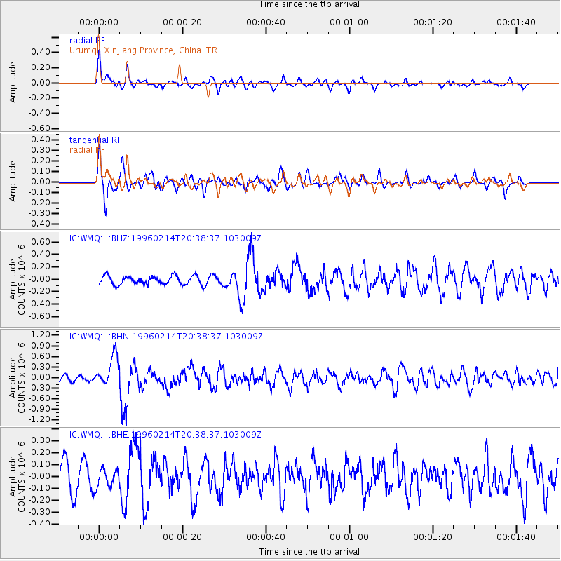
WMQ Urumqi, Xinjiang Province, China - Earthquake Result Viewer
*The percent match for this event was below the threshold and hence no stack was calculated.
| Earthquake location: |
Kuril Islands |
| Earthquake latitude/longitude: |
45.4/150.4 |
| Earthquake time(UTC): |
1996/02/14 (045) 20:31:06 GMT |
| Earthquake Depth: |
33 km |
| Earthquake Magnitude: |
5.9 MB, 5.2 MS, 5.8 UNKNOWN, 5.8 MW |
| Earthquake Catalog/Contributor: |
WHDF/NEIC |
|
| Network: |
IC New China Digital Seismograph Network |
| Station: |
WMQ Urumqi, Xinjiang Province, China |
| Lat/Lon: |
43.82 N/87.69 E |
| Elevation: |
903 m |
|
| Distance: |
43.6 deg |
| Az: |
291.279 deg |
| Baz: |
65.124 deg |
| Ray Param: |
$rayparam |
*The percent match for this event was below the threshold and hence was not used in the summary stack. |
|
| Radial Match: |
71.906876 % |
| Radial Bump: |
400 |
| Transverse Match: |
66.318565 % |
| Transverse Bump: |
400 |
| SOD ConfigId: |
4480 |
| Insert Time: |
2010-03-05 00:25:49.860 +0000 |
| GWidth: |
2.5 |
| Max Bumps: |
400 |
| Tol: |
0.001 |
|
Signal To Noise
| Channel | StoN | STA | LTA |
| IC:WMQ: :BHN:19960214T20:38:37.103009Z | 6.12274 | 4.3930518E-7 | 7.174977E-8 |
| IC:WMQ: :BHE:19960214T20:38:37.103009Z | 0.49314705 | 7.231444E-8 | 1.4663871E-7 |
| IC:WMQ: :BHZ:19960214T20:38:37.103009Z | 3.4464664 | 2.2304512E-7 | 6.471704E-8 |
| Arrivals |
| Ps | |
| PpPs | |
| PsPs/PpSs | |


