You are here: Home > Network List > US - United States National Seismic Network Stations List
> Station MSO Missoula, Montana, USA > Earthquake Result Viewer
MSO Missoula, Montana, USA - Earthquake Result Viewer
*The percent match for this event was below the threshold and hence no stack was calculated.
| Earthquake location: |
North Atlantic Ocean |
| Earthquake latitude/longitude: |
13.9/-58.5 |
| Earthquake time(UTC): |
2015/07/16 (197) 11:01:47 GMT |
| Earthquake Depth: |
13 km |
| Earthquake Magnitude: |
5.7 MWW, 5.6 MWB, 5.7 MWC |
| Earthquake Catalog/Contributor: |
NEIC PDE/NEIC COMCAT |
|
| Network: |
US United States National Seismic Network |
| Station: |
MSO Missoula, Montana, USA |
| Lat/Lon: |
46.83 N/113.94 W |
| Elevation: |
1264 m |
|
| Distance: |
56.5 deg |
| Az: |
317.314 deg |
| Baz: |
106.482 deg |
| Ray Param: |
$rayparam |
*The percent match for this event was below the threshold and hence was not used in the summary stack. |
|
| Radial Match: |
37.72981 % |
| Radial Bump: |
400 |
| Transverse Match: |
53.36049 % |
| Transverse Bump: |
400 |
| SOD ConfigId: |
1085051 |
| Insert Time: |
2015-07-30 11:31:46.941 +0000 |
| GWidth: |
2.5 |
| Max Bumps: |
400 |
| Tol: |
0.001 |
|
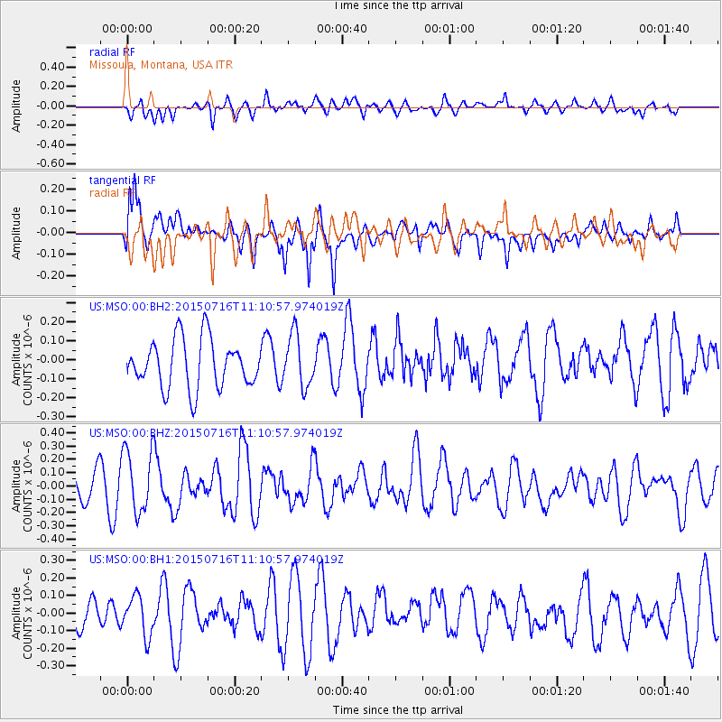
Signal To Noise
| Channel | StoN | STA | LTA |
| US:MSO:00:BHZ:20150716T11:10:57.974019Z | 1.9457642 | 2.3894827E-7 | 1.2280434E-7 |
| US:MSO:00:BH1:20150716T11:10:57.974019Z | 0.9953896 | 1.1422424E-7 | 1.14753306E-7 |
| US:MSO:00:BH2:20150716T11:10:57.974019Z | 1.0827303 | 1.3736388E-7 | 1.2686804E-7 |
| Arrivals |
| Ps | |
| PpPs | |
| PsPs/PpSs | |


