You are here: Home > Network List > CI - Caltech Regional Seismic Network Stations List
> Station BAR Barrett, Tecate, CA, USA > Earthquake Result Viewer
BAR Barrett, Tecate, CA, USA - Earthquake Result Viewer
| Earthquake location: |
Fox Islands, Aleutian Islands |
| Earthquake latitude/longitude: |
52.5/-168.0 |
| Earthquake time(UTC): |
2007/07/15 (196) 13:08:00 GMT |
| Earthquake Depth: |
10 km |
| Earthquake Magnitude: |
5.8 MB, 5.9 MS, 6.1 MW, 6.0 MW |
| Earthquake Catalog/Contributor: |
WHDF/NEIC |
|
| Network: |
CI Caltech Regional Seismic Network |
| Station: |
BAR Barrett, Tecate, CA, USA |
| Lat/Lon: |
32.68 N/116.67 W |
| Elevation: |
521 m |
|
| Distance: |
41.7 deg |
| Az: |
97.592 deg |
| Baz: |
314.038 deg |
| Ray Param: |
0.07365355 |
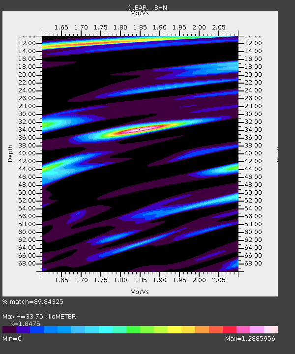
| Estimated Moho Depth: |
33.75 km |
| Estimated Crust Vp/Vs: |
1.85 |
| Assumed Crust Vp: |
6.264 km/s |
| Estimated Crust Vs: |
3.39 km/s |
| Estimated Crust Poisson's Ratio: |
0.29 |
|
| Radial Match: |
89.84325 % |
| Radial Bump: |
400 |
| Transverse Match: |
87.0756 % |
| Transverse Bump: |
400 |
| SOD ConfigId: |
2564 |
| Insert Time: |
2010-02-26 00:09:50.443 +0000 |
| GWidth: |
2.5 |
| Max Bumps: |
400 |
| Tol: |
0.001 |
|

Signal To Noise
| Channel | StoN | STA | LTA |
| CI:BAR: :BHN:20070715T13:15:18.436007Z | 2.7827868 | 2.322848E-7 | 8.347201E-8 |
| CI:BAR: :BHE:20070715T13:15:18.436007Z | 2.4349132 | 1.6501598E-7 | 6.7770785E-8 |
| CI:BAR: :BHZ:20070715T13:15:18.436007Z | 5.1957817 | 5.33032E-7 | 1.02589375E-7 |
| Arrivals |
| Ps | 4.9 SECOND |
| PpPs | 14 SECOND |
| PsPs/PpSs | 19 SECOND |


