You are here: Home > Network List > AV - Alaska Volcano Observatory Stations List
> Station MAPS Pakushin Southeast, Makushin Volcano, Alaska > Earthquake Result Viewer
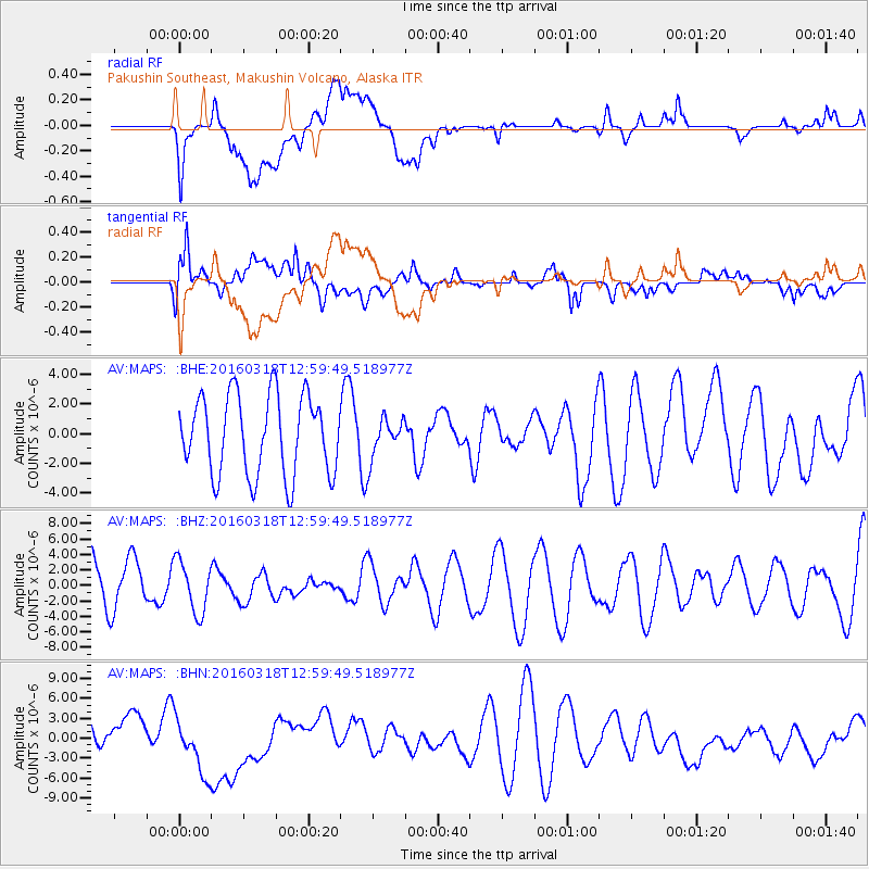
MAPS Pakushin Southeast, Makushin Volcano, Alaska - Earthquake Result Viewer
*The percent match for this event was below the threshold and hence no stack was calculated.
| Earthquake location: |
Santa Cruz Islands |
| Earthquake latitude/longitude: |
-12.5/166.5 |
| Earthquake time(UTC): |
2016/03/18 (078) 12:49:14 GMT |
| Earthquake Depth: |
42 km |
| Earthquake Magnitude: |
5.5 MWB |
| Earthquake Catalog/Contributor: |
NEIC PDE/NEIC COMCAT |
|
| Network: |
AV Alaska Volcano Observatory |
| Station: |
MAPS Pakushin Southeast, Makushin Volcano, Alaska |
| Lat/Lon: |
53.81 N/166.94 W |
| Elevation: |
333 m |
|
| Distance: |
69.8 deg |
| Az: |
16.394 deg |
| Baz: |
207.697 deg |
| Ray Param: |
$rayparam |
*The percent match for this event was below the threshold and hence was not used in the summary stack. |
|
| Radial Match: |
57.59584 % |
| Radial Bump: |
400 |
| Transverse Match: |
57.28843 % |
| Transverse Bump: |
400 |
| SOD ConfigId: |
7422571 |
| Insert Time: |
2019-04-22 01:13:20.808 +0000 |
| GWidth: |
2.5 |
| Max Bumps: |
400 |
| Tol: |
0.001 |
|
Signal To Noise
| Channel | StoN | STA | LTA |
| AV:MAPS: :BHZ:20160318T12:59:49.518977Z | 1.1151208 | 3.339998E-6 | 2.9951896E-6 |
| AV:MAPS: :BHN:20160318T12:59:49.518977Z | 1.9216644 | 4.50049E-6 | 2.341975E-6 |
| AV:MAPS: :BHE:20160318T12:59:49.518977Z | 0.37508553 | 1.0119489E-6 | 2.697915E-6 |
| Arrivals |
| Ps | |
| PpPs | |
| PsPs/PpSs | |


