You are here: Home > Network List > IC - New China Digital Seismograph Network Stations List
> Station WMQ Urumqi, Xinjiang Province, China > Earthquake Result Viewer
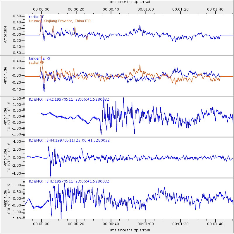
WMQ Urumqi, Xinjiang Province, China - Earthquake Result Viewer
*The percent match for this event was below the threshold and hence no stack was calculated.
| Earthquake location: |
Eastern Honshu, Japan |
| Earthquake latitude/longitude: |
37.1/140.9 |
| Earthquake time(UTC): |
1997/05/11 (131) 22:59:38 GMT |
| Earthquake Depth: |
49 km |
| Earthquake Magnitude: |
5.5 MB, 5.3 MS |
| Earthquake Catalog/Contributor: |
WHDF/NEIC |
|
| Network: |
IC New China Digital Seismograph Network |
| Station: |
WMQ Urumqi, Xinjiang Province, China |
| Lat/Lon: |
43.82 N/87.69 E |
| Elevation: |
903 m |
|
| Distance: |
40.5 deg |
| Az: |
296.692 deg |
| Baz: |
80.749 deg |
| Ray Param: |
$rayparam |
*The percent match for this event was below the threshold and hence was not used in the summary stack. |
|
| Radial Match: |
70.77483 % |
| Radial Bump: |
400 |
| Transverse Match: |
59.894028 % |
| Transverse Bump: |
400 |
| SOD ConfigId: |
4480 |
| Insert Time: |
2010-03-05 00:27:40.969 +0000 |
| GWidth: |
2.5 |
| Max Bumps: |
400 |
| Tol: |
0.001 |
|
Signal To Noise
| Channel | StoN | STA | LTA |
| IC:WMQ: :BHN:19970511T23:06:41.528003Z | 4.8447876 | 7.485989E-7 | 1.5451634E-7 |
| IC:WMQ: :BHE:19970511T23:06:41.528003Z | 1.4946519 | 5.0448455E-7 | 3.3752644E-7 |
| IC:WMQ: :BHZ:19970511T23:06:41.528003Z | 3.258202 | 5.404315E-7 | 1.65868E-7 |
| Arrivals |
| Ps | |
| PpPs | |
| PsPs/PpSs | |


