You are here: Home > Network List > IC - New China Digital Seismograph Network Stations List
> Station WMQ Urumqi, Xinjiang Province, China > Earthquake Result Viewer
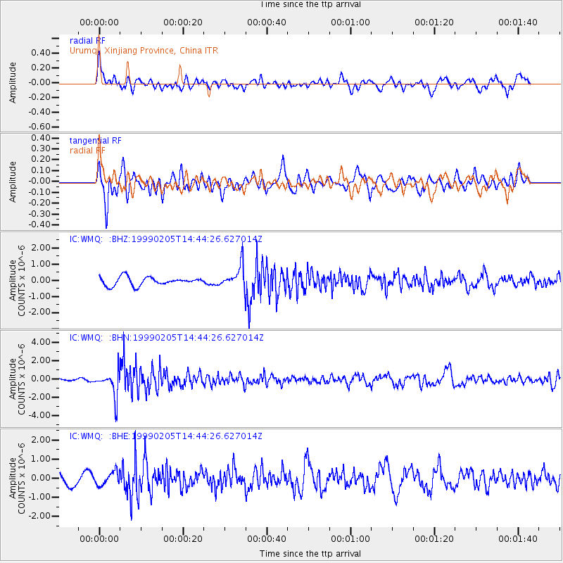
WMQ Urumqi, Xinjiang Province, China - Earthquake Result Viewer
*The percent match for this event was below the threshold and hence no stack was calculated.
| Earthquake location: |
Northwest Of Kuril Islands |
| Earthquake latitude/longitude: |
47.5/147.2 |
| Earthquake time(UTC): |
1999/02/05 (036) 14:37:53 GMT |
| Earthquake Depth: |
407 km |
| Earthquake Magnitude: |
6.0 MW, 5.4 MB, 5.8 MW |
| Earthquake Catalog/Contributor: |
WHDF/NEIC |
|
| Network: |
IC New China Digital Seismograph Network |
| Station: |
WMQ Urumqi, Xinjiang Province, China |
| Lat/Lon: |
43.82 N/87.69 E |
| Elevation: |
903 m |
|
| Distance: |
40.8 deg |
| Az: |
287.575 deg |
| Baz: |
63.247 deg |
| Ray Param: |
$rayparam |
*The percent match for this event was below the threshold and hence was not used in the summary stack. |
|
| Radial Match: |
59.307835 % |
| Radial Bump: |
400 |
| Transverse Match: |
59.436962 % |
| Transverse Bump: |
400 |
| SOD ConfigId: |
4480 |
| Insert Time: |
2010-03-05 00:27:49.563 +0000 |
| GWidth: |
2.5 |
| Max Bumps: |
400 |
| Tol: |
0.001 |
|
Signal To Noise
| Channel | StoN | STA | LTA |
| IC:WMQ: :BHN:19990205T14:44:26.627014Z | 9.548413 | 1.436132E-6 | 1.5040531E-7 |
| IC:WMQ: :BHE:19990205T14:44:26.627014Z | 1.4283161 | 3.6022132E-7 | 2.522E-7 |
| IC:WMQ: :BHZ:19990205T14:44:26.627014Z | 2.82801 | 7.293478E-7 | 2.579014E-7 |
| Arrivals |
| Ps | |
| PpPs | |
| PsPs/PpSs | |


