You are here: Home > Network List > TA - USArray Transportable Network (new EarthScope stations) Stations List
> Station Z41A Richland Creek Farm, El Dorado, AR, USA > Earthquake Result Viewer
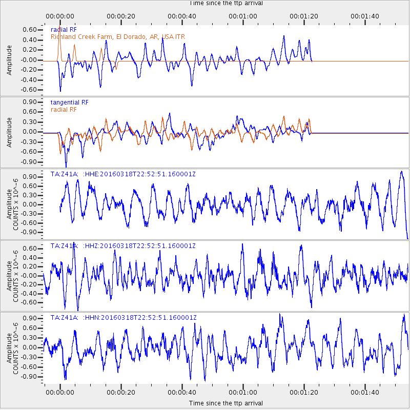
Z41A Richland Creek Farm, El Dorado, AR, USA - Earthquake Result Viewer
*The percent match for this event was below the threshold and hence no stack was calculated.
| Earthquake location: |
Vancouver Island, Canada Region |
| Earthquake latitude/longitude: |
49.7/-129.9 |
| Earthquake time(UTC): |
2016/03/18 (078) 22:46:56 GMT |
| Earthquake Depth: |
10 km |
| Earthquake Magnitude: |
5.5 MWW, 5.4 MWB, 5.5 MWC |
| Earthquake Catalog/Contributor: |
NEIC PDE/NEIC COMCAT |
|
| Network: |
TA USArray Transportable Network (new EarthScope stations) |
| Station: |
Z41A Richland Creek Farm, El Dorado, AR, USA |
| Lat/Lon: |
33.26 N/92.80 W |
| Elevation: |
62 m |
|
| Distance: |
31.9 deg |
| Az: |
106.884 deg |
| Baz: |
312.081 deg |
| Ray Param: |
$rayparam |
*The percent match for this event was below the threshold and hence was not used in the summary stack. |
|
| Radial Match: |
41.935993 % |
| Radial Bump: |
400 |
| Transverse Match: |
53.05494 % |
| Transverse Bump: |
400 |
| SOD ConfigId: |
7422571 |
| Insert Time: |
2019-04-22 01:27:04.713 +0000 |
| GWidth: |
2.5 |
| Max Bumps: |
400 |
| Tol: |
0.001 |
|
Signal To Noise
| Channel | StoN | STA | LTA |
| TA:Z41A: :HHZ:20160318T22:52:51.160001Z | 1.9514298 | 3.3558487E-7 | 1.7196871E-7 |
| TA:Z41A: :HHN:20160318T22:52:51.160001Z | 1.2545885 | 5.315719E-7 | 4.237022E-7 |
| TA:Z41A: :HHE:20160318T22:52:51.160001Z | 1.0788003 | 3.9631715E-7 | 3.673684E-7 |
| Arrivals |
| Ps | |
| PpPs | |
| PsPs/PpSs | |


