You are here: Home > Network List > 7A - Mid-Atlantic Geophysical Integrative Collaboration Stations List
> Station WTMN Standardsville, Virginia USA > Earthquake Result Viewer
WTMN Standardsville, Virginia USA - Earthquake Result Viewer
| Earthquake location: |
Andreanof Islands, Aleutian Is. |
| Earthquake latitude/longitude: |
51.5/-174.2 |
| Earthquake time(UTC): |
2016/03/19 (079) 01:35:12 GMT |
| Earthquake Depth: |
17 km |
| Earthquake Magnitude: |
6.0 MWW, 5.5 ML, 5.8 MWB |
| Earthquake Catalog/Contributor: |
NEIC PDE/NEIC COMCAT |
|
| Network: |
7A Mid-Atlantic Geophysical Integrative Collaboration |
| Station: |
WTMN Standardsville, Virginia USA |
| Lat/Lon: |
38.30 N/78.48 W |
| Elevation: |
178 m |
|
| Distance: |
64.4 deg |
| Az: |
60.258 deg |
| Baz: |
316.403 deg |
| Ray Param: |
0.058948196 |
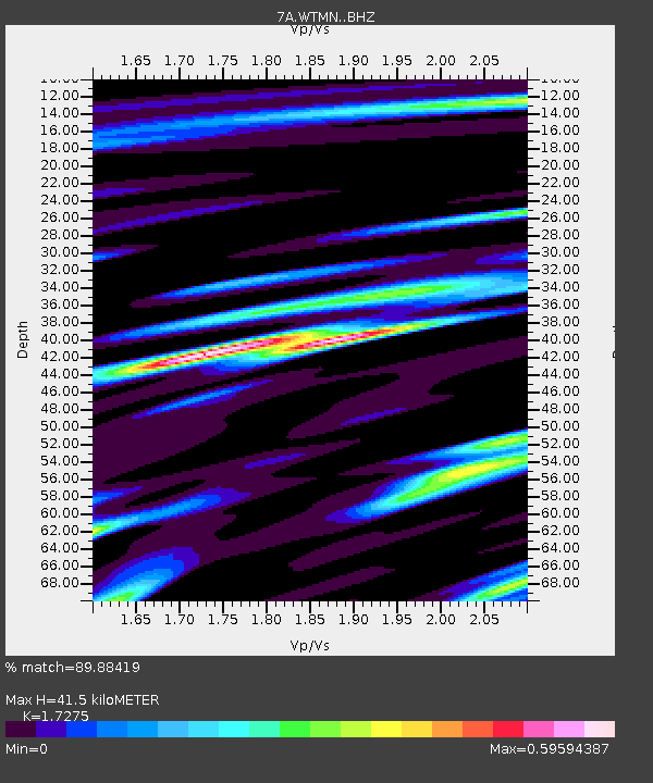
| Estimated Moho Depth: |
41.5 km |
| Estimated Crust Vp/Vs: |
1.73 |
| Assumed Crust Vp: |
6.159 km/s |
| Estimated Crust Vs: |
3.565 km/s |
| Estimated Crust Poisson's Ratio: |
0.25 |
|
| Radial Match: |
89.88419 % |
| Radial Bump: |
400 |
| Transverse Match: |
83.01154 % |
| Transverse Bump: |
400 |
| SOD ConfigId: |
7422571 |
| Insert Time: |
2019-04-22 01:28:36.653 +0000 |
| GWidth: |
2.5 |
| Max Bumps: |
400 |
| Tol: |
0.001 |
|

Signal To Noise
| Channel | StoN | STA | LTA |
| 7A:WTMN: :BHZ:20160319T01:45:15.574971Z | 9.268596 | 1.7285721E-6 | 1.8649774E-7 |
| 7A:WTMN: :BHN:20160319T01:45:15.574971Z | 6.4931827 | 6.9465915E-7 | 1.06982846E-7 |
| 7A:WTMN: :BHE:20160319T01:45:15.574971Z | 4.7460117 | 4.6708777E-7 | 9.8416905E-8 |
| Arrivals |
| Ps | 5.1 SECOND |
| PpPs | 18 SECOND |
| PsPs/PpSs | 23 SECOND |


