You are here: Home > Network List > CI - Caltech Regional Seismic Network Stations List
> Station BAR Barrett, Tecate, CA, USA > Earthquake Result Viewer
BAR Barrett, Tecate, CA, USA - Earthquake Result Viewer
| Earthquake location: |
New Britain Region, P.N.G. |
| Earthquake latitude/longitude: |
-5.2/150.9 |
| Earthquake time(UTC): |
1999/05/10 (130) 20:33:02 GMT |
| Earthquake Depth: |
138 km |
| Earthquake Magnitude: |
6.5 MB, 6.8 MS, 7.1 MW, 6.5 MB |
| Earthquake Catalog/Contributor: |
WHDF/NEIC |
|
| Network: |
CI Caltech Regional Seismic Network |
| Station: |
BAR Barrett, Tecate, CA, USA |
| Lat/Lon: |
32.68 N/116.67 W |
| Elevation: |
521 m |
|
| Distance: |
94.8 deg |
| Az: |
57.731 deg |
| Baz: |
266.982 deg |
| Ray Param: |
0.040844772 |
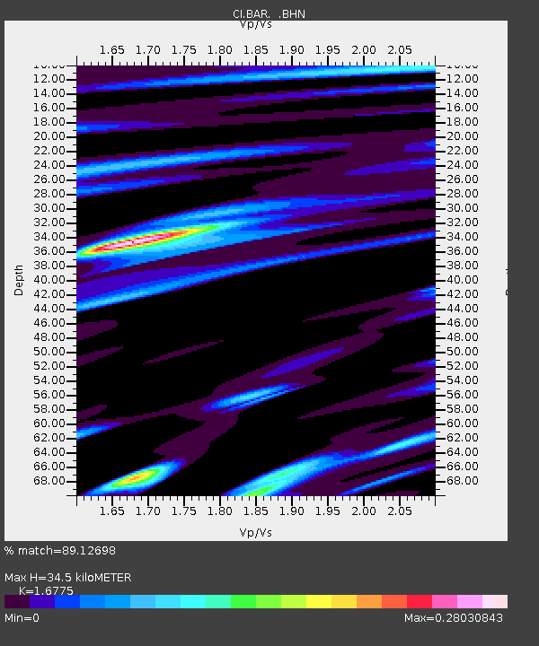
| Estimated Moho Depth: |
34.5 km |
| Estimated Crust Vp/Vs: |
1.68 |
| Assumed Crust Vp: |
6.264 km/s |
| Estimated Crust Vs: |
3.734 km/s |
| Estimated Crust Poisson's Ratio: |
0.22 |
|
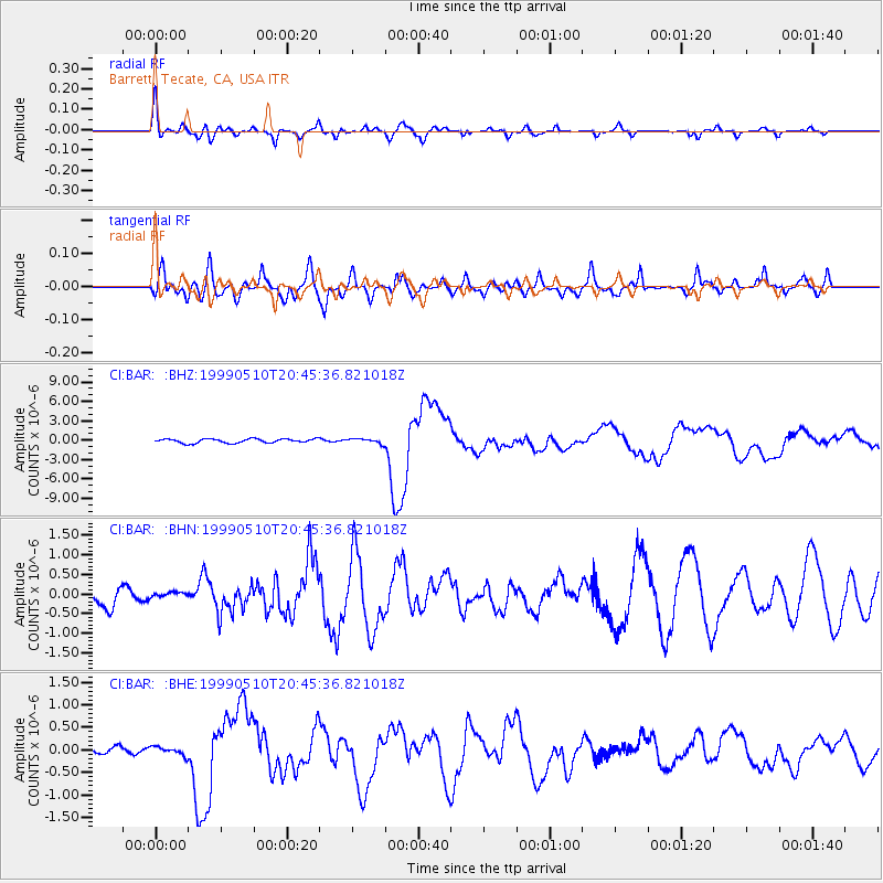
| Radial Match: |
89.12698 % |
| Radial Bump: |
400 |
| Transverse Match: |
63.805862 % |
| Transverse Bump: |
400 |
| SOD ConfigId: |
3770 |
| Insert Time: |
2010-02-26 00:10:05.245 +0000 |
| GWidth: |
2.5 |
| Max Bumps: |
400 |
| Tol: |
0.001 |
|
Signal To Noise
| Channel | StoN | STA | LTA |
| CI:BAR: :BHN:19990510T20:45:36.821018Z | 0.14999922 | 5.509827E-8 | 3.6732374E-7 |
| CI:BAR: :BHE:19990510T20:45:36.821018Z | 0.88696706 | 9.3281976E-8 | 1.0516961E-7 |
| CI:BAR: :BHZ:19990510T20:45:36.821018Z | 1.2370315 | 3.7751838E-7 | 3.051809E-7 |
| Arrivals |
| Ps | 3.8 SECOND |
| PpPs | 14 SECOND |
| PsPs/PpSs | 18 SECOND |


