You are here: Home > Network List > GS - US Geological Survey Networks Stations List
> Station DEC12 Decatur Surface Seismic Site, Decatur, IL, USA > Earthquake Result Viewer
DEC12 Decatur Surface Seismic Site, Decatur, IL, USA - Earthquake Result Viewer
| Earthquake location: |
North Atlantic Ocean |
| Earthquake latitude/longitude: |
13.9/-58.5 |
| Earthquake time(UTC): |
2015/07/16 (197) 15:16:32 GMT |
| Earthquake Depth: |
10 km |
| Earthquake Magnitude: |
6.5 MWW, 6.5 MWC, 6.5 MWB, 6.5 MI |
| Earthquake Catalog/Contributor: |
NEIC PDE/NEIC COMCAT |
|
| Network: |
GS US Geological Survey Networks |
| Station: |
DEC12 Decatur Surface Seismic Site, Decatur, IL, USA |
| Lat/Lon: |
39.91 N/88.91 W |
| Elevation: |
208 m |
|
| Distance: |
37.2 deg |
| Az: |
319.965 deg |
| Baz: |
125.684 deg |
| Ray Param: |
0.07627594 |
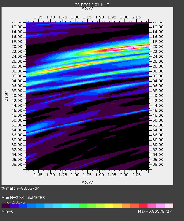
| Estimated Moho Depth: |
20.0 km |
| Estimated Crust Vp/Vs: |
2.04 |
| Assumed Crust Vp: |
6.444 km/s |
| Estimated Crust Vs: |
3.163 km/s |
| Estimated Crust Poisson's Ratio: |
0.34 |
|
| Radial Match: |
83.55704 % |
| Radial Bump: |
400 |
| Transverse Match: |
50.365696 % |
| Transverse Bump: |
400 |
| SOD ConfigId: |
1085051 |
| Insert Time: |
2015-07-30 15:33:40.066 +0000 |
| GWidth: |
2.5 |
| Max Bumps: |
400 |
| Tol: |
0.001 |
|
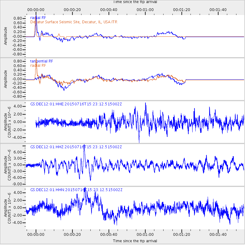
Signal To Noise
| Channel | StoN | STA | LTA |
| GS:DEC12:01:HHZ:20150716T15:23:12.515002Z | 3.3245912 | 1.1914046E-6 | 3.5836123E-7 |
| GS:DEC12:01:HHN:20150716T15:23:12.515002Z | 1.5492535 | 1.8658191E-6 | 1.2043344E-6 |
| GS:DEC12:01:HHE:20150716T15:23:12.515002Z | 1.5062028 | 7.8075186E-7 | 5.1835775E-7 |
| Arrivals |
| Ps | 3.4 SECOND |
| PpPs | 8.8 SECOND |
| PsPs/PpSs | 12 SECOND |


