You are here: Home > Network List > KS - Korea National Seismograph Network- KMA Stations List
> Station NAWB Namwon, South Korea > Earthquake Result Viewer
NAWB Namwon, South Korea - Earthquake Result Viewer
| Earthquake location: |
Andreanof Islands, Aleutian Is. |
| Earthquake latitude/longitude: |
51.5/-174.2 |
| Earthquake time(UTC): |
2016/03/19 (079) 01:35:12 GMT |
| Earthquake Depth: |
17 km |
| Earthquake Magnitude: |
6.0 MWW, 5.5 ML, 5.8 MWB |
| Earthquake Catalog/Contributor: |
NEIC PDE/NEIC COMCAT |
|
| Network: |
KS Korea National Seismograph Network- KMA |
| Station: |
NAWB Namwon, South Korea |
| Lat/Lon: |
35.42 N/127.40 E |
| Elevation: |
176 m |
|
| Distance: |
44.1 deg |
| Az: |
272.155 deg |
| Baz: |
49.869 deg |
| Ray Param: |
0.072106905 |
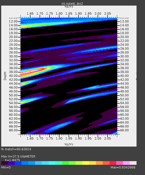
| Estimated Moho Depth: |
37.5 km |
| Estimated Crust Vp/Vs: |
1.65 |
| Assumed Crust Vp: |
6.459 km/s |
| Estimated Crust Vs: |
3.921 km/s |
| Estimated Crust Poisson's Ratio: |
0.21 |
|
| Radial Match: |
80.63824 % |
| Radial Bump: |
358 |
| Transverse Match: |
75.18896 % |
| Transverse Bump: |
400 |
| SOD ConfigId: |
7422571 |
| Insert Time: |
2019-04-22 01:32:27.764 +0000 |
| GWidth: |
2.5 |
| Max Bumps: |
400 |
| Tol: |
0.001 |
|

Signal To Noise
| Channel | StoN | STA | LTA |
| KS:NAWB: :BHZ:20160319T01:42:48.969014Z | 4.8299336 | 2.3220055E-6 | 4.8075304E-7 |
| KS:NAWB: :BHN:20160319T01:42:48.969014Z | 3.1222322 | 1.1409969E-6 | 3.6544267E-7 |
| KS:NAWB: :BHE:20160319T01:42:48.969014Z | 1.2230145 | 4.0268236E-7 | 3.2925396E-7 |
| Arrivals |
| Ps | 4.0 SECOND |
| PpPs | 14 SECOND |
| PsPs/PpSs | 18 SECOND |


