You are here: Home > Network List > N4 - Central and EAstern US Network Stations List
> Station B35B Bob, Littlefork, MN, USA > Earthquake Result Viewer
B35B Bob, Littlefork, MN, USA - Earthquake Result Viewer
| Earthquake location: |
Andreanof Islands, Aleutian Is. |
| Earthquake latitude/longitude: |
51.5/-174.2 |
| Earthquake time(UTC): |
2016/03/19 (079) 01:35:12 GMT |
| Earthquake Depth: |
17 km |
| Earthquake Magnitude: |
6.0 MWW, 5.5 ML, 5.8 MWB |
| Earthquake Catalog/Contributor: |
NEIC PDE/NEIC COMCAT |
|
| Network: |
N4 Central and EAstern US Network |
| Station: |
B35B Bob, Littlefork, MN, USA |
| Lat/Lon: |
48.36 N/93.73 W |
| Elevation: |
354 m |
|
| Distance: |
49.4 deg |
| Az: |
60.001 deg |
| Baz: |
305.761 deg |
| Ray Param: |
0.06869121 |
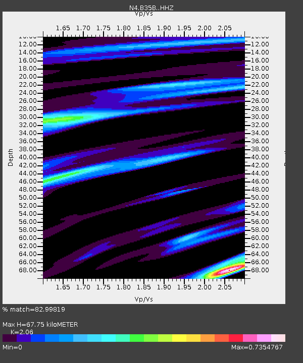
| Estimated Moho Depth: |
67.75 km |
| Estimated Crust Vp/Vs: |
2.06 |
| Assumed Crust Vp: |
6.419 km/s |
| Estimated Crust Vs: |
3.116 km/s |
| Estimated Crust Poisson's Ratio: |
0.35 |
|
| Radial Match: |
82.99819 % |
| Radial Bump: |
400 |
| Transverse Match: |
59.518692 % |
| Transverse Bump: |
400 |
| SOD ConfigId: |
7422571 |
| Insert Time: |
2019-04-22 01:33:32.074 +0000 |
| GWidth: |
2.5 |
| Max Bumps: |
400 |
| Tol: |
0.001 |
|

Signal To Noise
| Channel | StoN | STA | LTA |
| N4:B35B: :HHZ:20160319T01:43:29.74001Z | 3.4563434 | 1.3521246E-6 | 3.912009E-7 |
| N4:B35B: :HHN:20160319T01:43:29.74001Z | 2.0438228 | 4.3369002E-7 | 2.1219552E-7 |
| N4:B35B: :HHE:20160319T01:43:29.74001Z | 4.3345323 | 7.29067E-7 | 1.6819968E-7 |
| Arrivals |
| Ps | 12 SECOND |
| PpPs | 31 SECOND |
| PsPs/PpSs | 42 SECOND |


