You are here: Home > Network List > N4 - Central and EAstern US Network Stations List
> Station R50A Paris, KY, USA > Earthquake Result Viewer
R50A Paris, KY, USA - Earthquake Result Viewer
| Earthquake location: |
Andreanof Islands, Aleutian Is. |
| Earthquake latitude/longitude: |
51.5/-174.2 |
| Earthquake time(UTC): |
2016/03/19 (079) 01:35:12 GMT |
| Earthquake Depth: |
17 km |
| Earthquake Magnitude: |
6.0 MWW, 5.5 ML, 5.8 MWB |
| Earthquake Catalog/Contributor: |
NEIC PDE/NEIC COMCAT |
|
| Network: |
N4 Central and EAstern US Network |
| Station: |
R50A Paris, KY, USA |
| Lat/Lon: |
38.28 N/84.33 W |
| Elevation: |
255 m |
|
| Distance: |
61.2 deg |
| Az: |
63.959 deg |
| Baz: |
314.485 deg |
| Ray Param: |
0.061043486 |
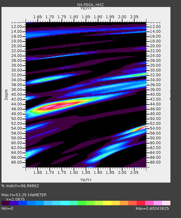
| Estimated Moho Depth: |
53.25 km |
| Estimated Crust Vp/Vs: |
2.10 |
| Assumed Crust Vp: |
6.498 km/s |
| Estimated Crust Vs: |
3.098 km/s |
| Estimated Crust Poisson's Ratio: |
0.35 |
|
| Radial Match: |
86.96962 % |
| Radial Bump: |
399 |
| Transverse Match: |
70.22292 % |
| Transverse Bump: |
400 |
| SOD ConfigId: |
7422571 |
| Insert Time: |
2019-04-22 01:34:43.647 +0000 |
| GWidth: |
2.5 |
| Max Bumps: |
400 |
| Tol: |
0.001 |
|

Signal To Noise
| Channel | StoN | STA | LTA |
| N4:R50A: :HHZ:20160319T01:44:54.139973Z | 6.9047713 | 1.0035811E-6 | 1.4534602E-7 |
| N4:R50A: :HHN:20160319T01:44:54.139973Z | 3.3412144 | 3.9775597E-7 | 1.19045325E-7 |
| N4:R50A: :HHE:20160319T01:44:54.139973Z | 3.646637 | 4.95808E-7 | 1.3596309E-7 |
| Arrivals |
| Ps | 9.4 SECOND |
| PpPs | 24 SECOND |
| PsPs/PpSs | 34 SECOND |


