You are here: Home > Network List > CI - Caltech Regional Seismic Network Stations List
> Station BAR Barrett, Tecate, CA, USA > Earthquake Result Viewer
BAR Barrett, Tecate, CA, USA - Earthquake Result Viewer
| Earthquake location: |
Kodiak Island Region, Alaska |
| Earthquake latitude/longitude: |
56.4/-152.9 |
| Earthquake time(UTC): |
1999/05/07 (127) 14:13:52 GMT |
| Earthquake Depth: |
20 km |
| Earthquake Magnitude: |
5.7 MB, 6.1 MS, 6.4 MW, 5.7 ME |
| Earthquake Catalog/Contributor: |
WHDF/NEIC |
|
| Network: |
CI Caltech Regional Seismic Network |
| Station: |
BAR Barrett, Tecate, CA, USA |
| Lat/Lon: |
32.68 N/116.67 W |
| Elevation: |
521 m |
|
| Distance: |
34.4 deg |
| Az: |
118.124 deg |
| Baz: |
324.468 deg |
| Ray Param: |
0.07771261 |
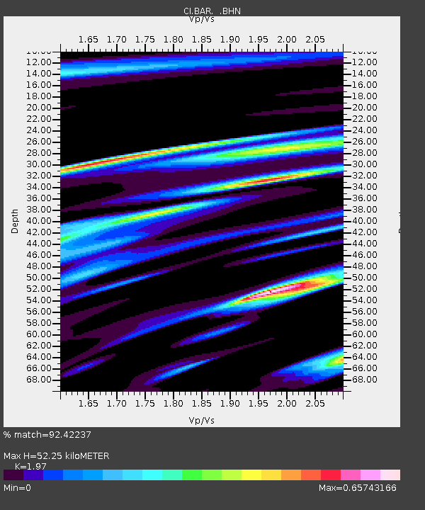
| Estimated Moho Depth: |
52.25 km |
| Estimated Crust Vp/Vs: |
1.97 |
| Assumed Crust Vp: |
6.264 km/s |
| Estimated Crust Vs: |
3.18 km/s |
| Estimated Crust Poisson's Ratio: |
0.33 |
|
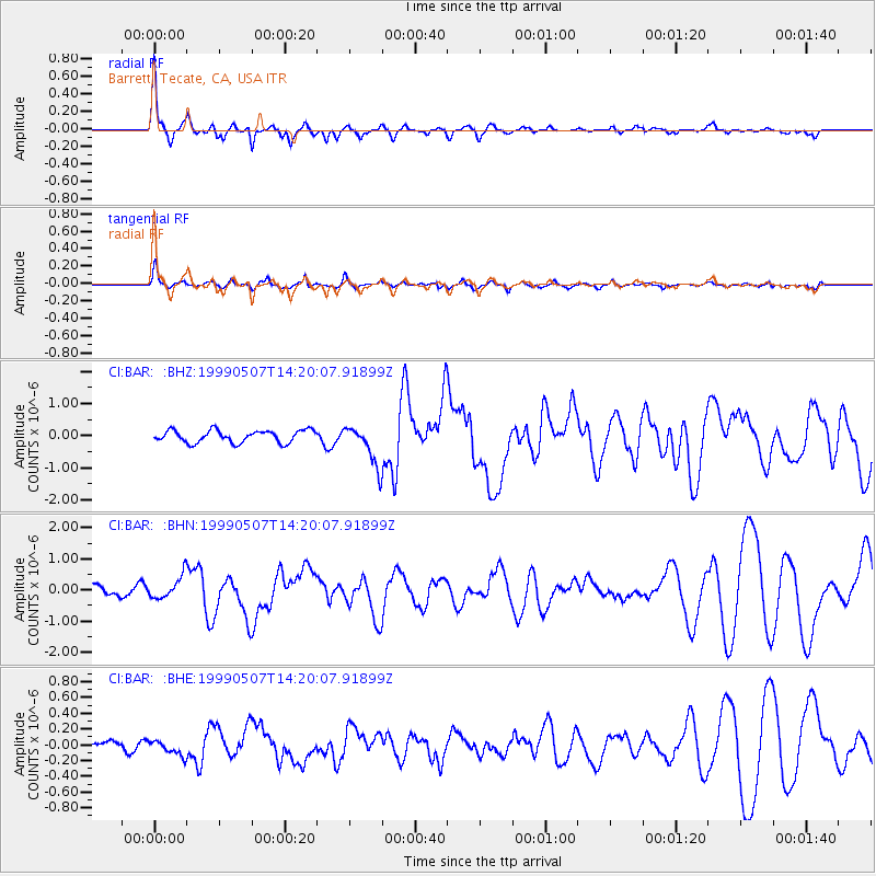
| Radial Match: |
92.42237 % |
| Radial Bump: |
312 |
| Transverse Match: |
74.7878 % |
| Transverse Bump: |
400 |
| SOD ConfigId: |
3787 |
| Insert Time: |
2010-02-26 00:10:10.072 +0000 |
| GWidth: |
2.5 |
| Max Bumps: |
400 |
| Tol: |
0.001 |
|
Signal To Noise
| Channel | StoN | STA | LTA |
| CI:BAR: :BHN:19990507T14:20:07.91899Z | 2.693935 | 3.6741704E-7 | 1.3638676E-7 |
| CI:BAR: :BHE:19990507T14:20:07.91899Z | 1.5772007 | 9.473954E-8 | 6.006816E-8 |
| CI:BAR: :BHZ:19990507T14:20:07.91899Z | 3.3055897 | 6.3010737E-7 | 1.9061875E-7 |
| Arrivals |
| Ps | 8.6 SECOND |
| PpPs | 23 SECOND |
| PsPs/PpSs | 32 SECOND |


