You are here: Home > Network List > NM - Cooperative New Madrid Seismic Network Stations List
> Station UTMT Martin, TN > Earthquake Result Viewer
UTMT Martin, TN - Earthquake Result Viewer
| Earthquake location: |
Andreanof Islands, Aleutian Is. |
| Earthquake latitude/longitude: |
51.5/-174.2 |
| Earthquake time(UTC): |
2016/03/19 (079) 01:35:12 GMT |
| Earthquake Depth: |
17 km |
| Earthquake Magnitude: |
6.0 MWW, 5.5 ML, 5.8 MWB |
| Earthquake Catalog/Contributor: |
NEIC PDE/NEIC COMCAT |
|
| Network: |
NM Cooperative New Madrid Seismic Network |
| Station: |
UTMT Martin, TN |
| Lat/Lon: |
36.35 N/88.86 W |
| Elevation: |
110 m |
|
| Distance: |
59.9 deg |
| Az: |
68.442 deg |
| Baz: |
313.953 deg |
| Ray Param: |
0.0618662 |
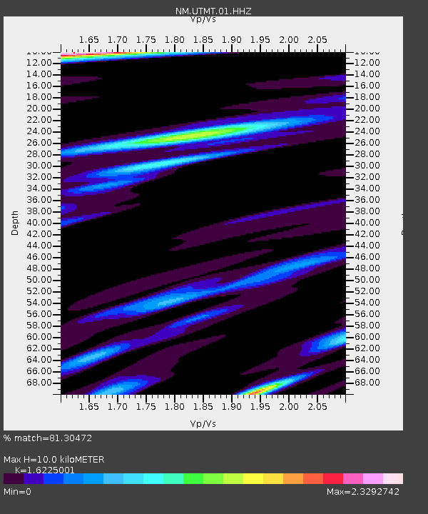
| Estimated Moho Depth: |
10.0 km |
| Estimated Crust Vp/Vs: |
1.62 |
| Assumed Crust Vp: |
6.444 km/s |
| Estimated Crust Vs: |
3.972 km/s |
| Estimated Crust Poisson's Ratio: |
0.19 |
|
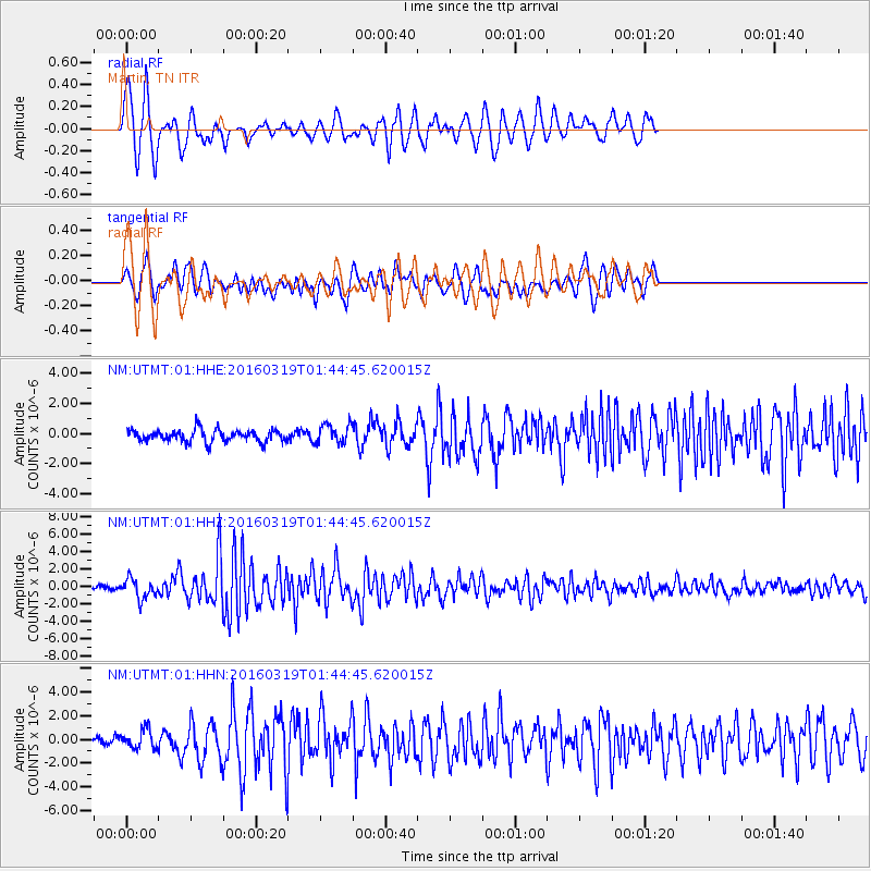
| Radial Match: |
81.30472 % |
| Radial Bump: |
400 |
| Transverse Match: |
71.95612 % |
| Transverse Bump: |
400 |
| SOD ConfigId: |
7422571 |
| Insert Time: |
2019-04-22 01:35:29.941 +0000 |
| GWidth: |
2.5 |
| Max Bumps: |
400 |
| Tol: |
0.001 |
|
Signal To Noise
| Channel | StoN | STA | LTA |
| NM:UTMT:01:HHZ:20160319T01:44:45.620015Z | 5.350785 | 1.126343E-6 | 2.1050053E-7 |
| NM:UTMT:01:HHN:20160319T01:44:45.620015Z | 1.298419 | 8.040757E-7 | 6.1927284E-7 |
| NM:UTMT:01:HHE:20160319T01:44:45.620015Z | 1.647993 | 6.594269E-7 | 4.0013938E-7 |
| Arrivals |
| Ps | 1.0 SECOND |
| PpPs | 3.9 SECOND |
| PsPs/PpSs | 4.9 SECOND |


