You are here: Home > Network List > PO - Portable Observatories for Lithospheric Analysis and Research Investigating Seis Stations List
> Station LATQ La Tuque, Quebec, QC > Earthquake Result Viewer
LATQ La Tuque, Quebec, QC - Earthquake Result Viewer
| Earthquake location: |
Andreanof Islands, Aleutian Is. |
| Earthquake latitude/longitude: |
51.5/-174.2 |
| Earthquake time(UTC): |
2016/03/19 (079) 01:35:12 GMT |
| Earthquake Depth: |
17 km |
| Earthquake Magnitude: |
6.0 MWW, 5.5 ML, 5.8 MWB |
| Earthquake Catalog/Contributor: |
NEIC PDE/NEIC COMCAT |
|
| Network: |
PO Portable Observatories for Lithospheric Analysis and Research Investigating Seis |
| Station: |
LATQ La Tuque, Quebec, QC |
| Lat/Lon: |
47.38 N/72.78 W |
| Elevation: |
163 m |
|
| Distance: |
60.8 deg |
| Az: |
49.752 deg |
| Baz: |
315.422 deg |
| Ray Param: |
0.06130206 |
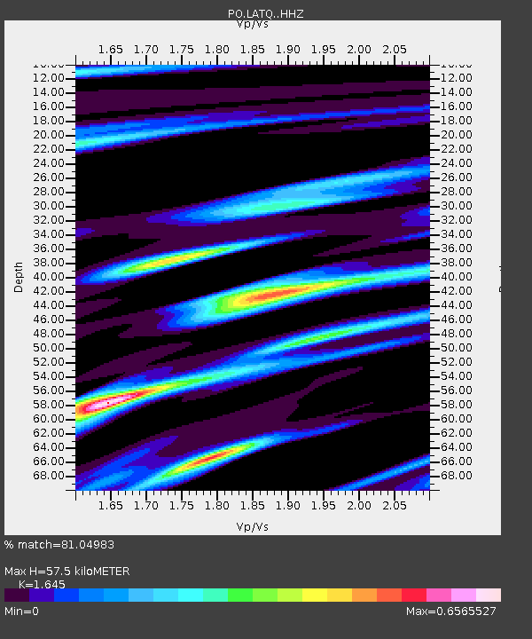
| Estimated Moho Depth: |
57.5 km |
| Estimated Crust Vp/Vs: |
1.64 |
| Assumed Crust Vp: |
6.61 km/s |
| Estimated Crust Vs: |
4.018 km/s |
| Estimated Crust Poisson's Ratio: |
0.21 |
|
| Radial Match: |
81.04983 % |
| Radial Bump: |
266 |
| Transverse Match: |
70.11931 % |
| Transverse Bump: |
400 |
| SOD ConfigId: |
7422571 |
| Insert Time: |
2019-04-22 01:37:04.782 +0000 |
| GWidth: |
2.5 |
| Max Bumps: |
400 |
| Tol: |
0.001 |
|

Signal To Noise
| Channel | StoN | STA | LTA |
| PO:LATQ: :HHZ:20160319T01:44:51.539998Z | 5.0276356 | 1.6803516E-6 | 3.3422302E-7 |
| PO:LATQ: :HHN:20160319T01:44:51.539998Z | 3.4266021 | 7.224244E-7 | 2.108282E-7 |
| PO:LATQ: :HHE:20160319T01:44:51.539998Z | 3.7420168 | 6.8009825E-7 | 1.8174644E-7 |
| Arrivals |
| Ps | 5.9 SECOND |
| PpPs | 22 SECOND |
| PsPs/PpSs | 28 SECOND |


