You are here: Home > Network List > TA - USArray Transportable Network (new EarthScope stations) Stations List
> Station M54A Oil Creek State Park, Oil City, PA, USA > Earthquake Result Viewer
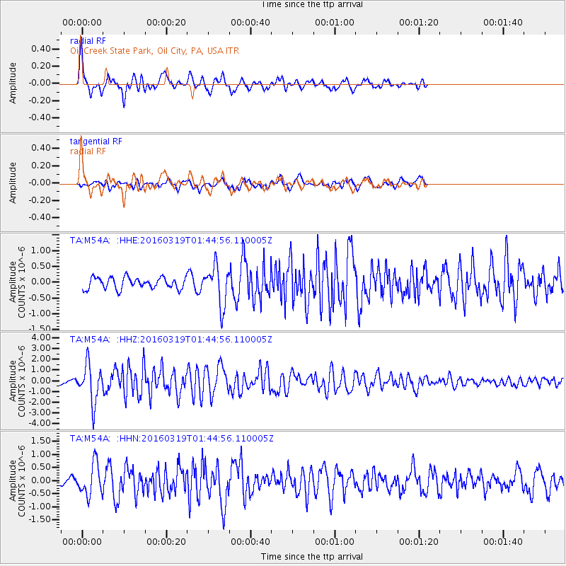
M54A Oil Creek State Park, Oil City, PA, USA - Earthquake Result Viewer

| Earthquake location: |
Andreanof Islands, Aleutian Is. |
| Earthquake latitude/longitude: |
51.5/-174.2 |
| Earthquake time(UTC): |
2016/03/19 (079) 01:35:12 GMT |
| Earthquake Depth: |
17 km |
| Earthquake Magnitude: |
6.0 MWW, 5.5 ML, 5.8 MWB |
| Earthquake Catalog/Contributor: |
NEIC PDE/NEIC COMCAT |
|
| Network: |
TA USArray Transportable Network (new EarthScope stations) |
| Station: |
M54A Oil Creek State Park, Oil City, PA, USA |
| Lat/Lon: |
41.51 N/79.66 W |
| Elevation: |
488 m |
|
| Distance: |
61.4 deg |
| Az: |
58.472 deg |
| Baz: |
314.83 deg |
| Ray Param: |
0.06085541 |
| Estimated Moho Depth: |
69.75 km |
| Estimated Crust Vp/Vs: |
1.65 |
| Assumed Crust Vp: |
6.121 km/s |
| Estimated Crust Vs: |
3.698 km/s |
| Estimated Crust Poisson's Ratio: |
0.21 |
|
| Radial Match: |
84.304474 % |
| Radial Bump: |
400 |
| Transverse Match: |
63.68143 % |
| Transverse Bump: |
400 |
| SOD ConfigId: |
7422571 |
| Insert Time: |
2019-04-22 01:38:09.062 +0000 |
| GWidth: |
2.5 |
| Max Bumps: |
400 |
| Tol: |
0.001 |
|
Signal To Noise
| Channel | StoN | STA | LTA |
| TA:M54A: :HHZ:20160319T01:44:56.110005Z | 10.405161 | 1.7935791E-6 | 1.7237399E-7 |
| TA:M54A: :HHN:20160319T01:44:56.110005Z | 3.6599698 | 6.25347E-7 | 1.7086124E-7 |
| TA:M54A: :HHE:20160319T01:44:56.110005Z | 3.557526 | 6.5069105E-7 | 1.829055E-7 |
| Arrivals |
| Ps | 7.8 SECOND |
| PpPs | 29 SECOND |
| PsPs/PpSs | 37 SECOND |


