You are here: Home > Network List > TA - USArray Transportable Network (new EarthScope stations) Stations List
> Station X43A Marvell, AR, USA > Earthquake Result Viewer
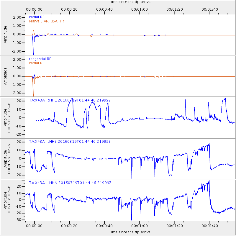
X43A Marvell, AR, USA - Earthquake Result Viewer
*The percent match for this event was below the threshold and hence no stack was calculated.
| Earthquake location: |
Andreanof Islands, Aleutian Is. |
| Earthquake latitude/longitude: |
51.5/-174.2 |
| Earthquake time(UTC): |
2016/03/19 (079) 01:35:12 GMT |
| Earthquake Depth: |
17 km |
| Earthquake Magnitude: |
6.0 MWW, 5.5 ML, 5.8 MWB |
| Earthquake Catalog/Contributor: |
NEIC PDE/NEIC COMCAT |
|
| Network: |
TA USArray Transportable Network (new EarthScope stations) |
| Station: |
X43A Marvell, AR, USA |
| Lat/Lon: |
34.52 N/90.88 W |
| Elevation: |
53 m |
|
| Distance: |
60.0 deg |
| Az: |
71.283 deg |
| Baz: |
314.211 deg |
| Ray Param: |
$rayparam |
*The percent match for this event was below the threshold and hence was not used in the summary stack. |
|
| Radial Match: |
98.38197 % |
| Radial Bump: |
94 |
| Transverse Match: |
48.992943 % |
| Transverse Bump: |
400 |
| SOD ConfigId: |
7422571 |
| Insert Time: |
2019-04-22 01:38:30.981 +0000 |
| GWidth: |
2.5 |
| Max Bumps: |
400 |
| Tol: |
0.001 |
|
Signal To Noise
| Channel | StoN | STA | LTA |
| TA:X43A: :HHZ:20160319T01:44:46.21999Z | 1.7384747 | 1.2431149E-5 | 7.1506065E-6 |
| TA:X43A: :HHN:20160319T01:44:46.21999Z | 1.6427368 | 1.2888545E-5 | 7.845776E-6 |
| TA:X43A: :HHE:20160319T01:44:46.21999Z | 1.784767 | 1.4848216E-5 | 8.3194145E-6 |
| Arrivals |
| Ps | |
| PpPs | |
| PsPs/PpSs | |


