You are here: Home > Network List > TM - Thai Seismic Monitoring Network Stations List
> Station MHIT MHIT Phase1 > Earthquake Result Viewer
MHIT MHIT Phase1 - Earthquake Result Viewer
| Earthquake location: |
Andreanof Islands, Aleutian Is. |
| Earthquake latitude/longitude: |
51.5/-174.2 |
| Earthquake time(UTC): |
2016/03/19 (079) 01:35:12 GMT |
| Earthquake Depth: |
17 km |
| Earthquake Magnitude: |
6.0 MWW, 5.5 ML, 5.8 MWB |
| Earthquake Catalog/Contributor: |
NEIC PDE/NEIC COMCAT |
|
| Network: |
TM Thai Seismic Monitoring Network |
| Station: |
MHIT MHIT Phase1 |
| Lat/Lon: |
19.31 N/97.96 E |
| Elevation: |
270 m |
|
| Distance: |
73.8 deg |
| Az: |
280.634 deg |
| Baz: |
40.566 deg |
| Ray Param: |
0.05276158 |
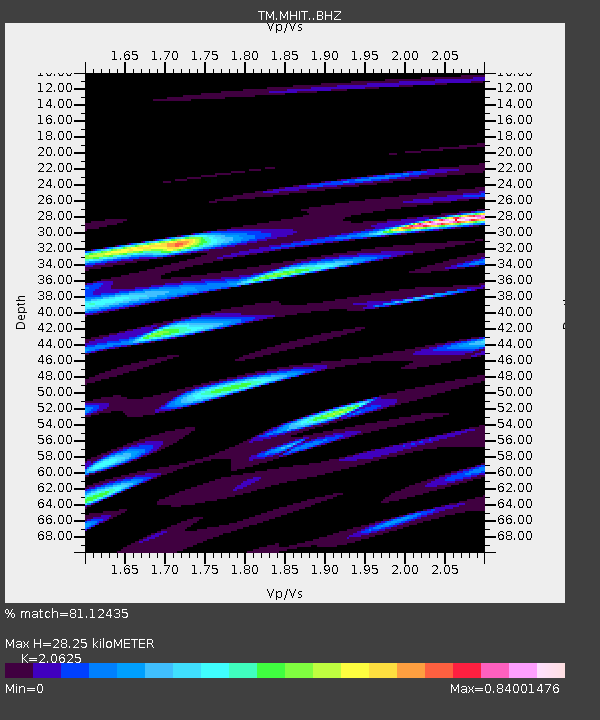
| Estimated Moho Depth: |
28.25 km |
| Estimated Crust Vp/Vs: |
2.06 |
| Assumed Crust Vp: |
6.316 km/s |
| Estimated Crust Vs: |
3.062 km/s |
| Estimated Crust Poisson's Ratio: |
0.35 |
|
| Radial Match: |
81.12435 % |
| Radial Bump: |
400 |
| Transverse Match: |
88.14205 % |
| Transverse Bump: |
397 |
| SOD ConfigId: |
7422571 |
| Insert Time: |
2019-04-22 01:38:49.378 +0000 |
| GWidth: |
2.5 |
| Max Bumps: |
400 |
| Tol: |
0.001 |
|

Signal To Noise
| Channel | StoN | STA | LTA |
| TM:MHIT: :BHZ:20160319T01:46:14.46999Z | 10.410431 | 1.355442E-6 | 1.3020038E-7 |
| TM:MHIT: :BHN:20160319T01:46:14.46999Z | 7.460087 | 1.0546762E-6 | 1.4137586E-7 |
| TM:MHIT: :BHE:20160319T01:46:14.46999Z | 1.4266747 | 2.3595375E-7 | 1.6538722E-7 |
| Arrivals |
| Ps | 4.9 SECOND |
| PpPs | 13 SECOND |
| PsPs/PpSs | 18 SECOND |


