You are here: Home > Network List > IW - Intermountain West Stations List
> Station SMCO Snowmass, Colorado, USA > Earthquake Result Viewer
SMCO Snowmass, Colorado, USA - Earthquake Result Viewer
| Earthquake location: |
North Atlantic Ocean |
| Earthquake latitude/longitude: |
13.9/-58.5 |
| Earthquake time(UTC): |
2015/07/16 (197) 15:16:32 GMT |
| Earthquake Depth: |
10 km |
| Earthquake Magnitude: |
6.5 MWW, 6.5 MWC, 6.5 MWB, 6.5 MI |
| Earthquake Catalog/Contributor: |
NEIC PDE/NEIC COMCAT |
|
| Network: |
IW Intermountain West |
| Station: |
SMCO Snowmass, Colorado, USA |
| Lat/Lon: |
39.18 N/106.97 W |
| Elevation: |
3435 m |
|
| Distance: |
49.4 deg |
| Az: |
310.027 deg |
| Baz: |
106.887 deg |
| Ray Param: |
0.06872116 |
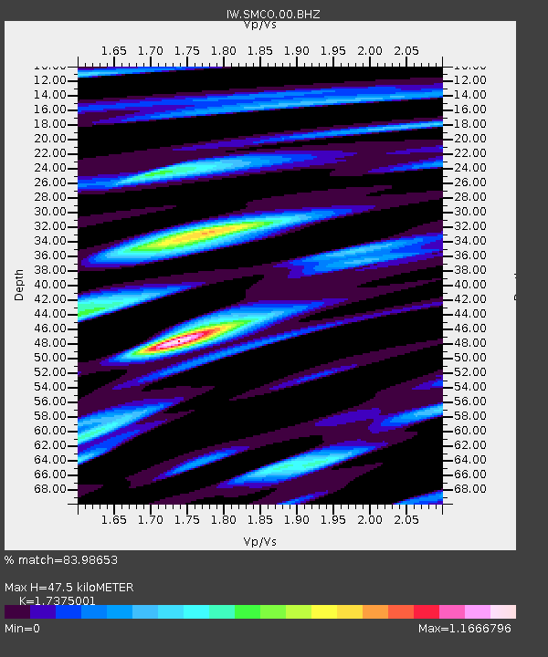
| Estimated Moho Depth: |
47.5 km |
| Estimated Crust Vp/Vs: |
1.74 |
| Assumed Crust Vp: |
6.306 km/s |
| Estimated Crust Vs: |
3.629 km/s |
| Estimated Crust Poisson's Ratio: |
0.25 |
|
| Radial Match: |
83.98653 % |
| Radial Bump: |
400 |
| Transverse Match: |
78.55139 % |
| Transverse Bump: |
400 |
| SOD ConfigId: |
1085051 |
| Insert Time: |
2015-07-30 15:37:19.197 +0000 |
| GWidth: |
2.5 |
| Max Bumps: |
400 |
| Tol: |
0.001 |
|

Signal To Noise
| Channel | StoN | STA | LTA |
| IW:SMCO:00:BHZ:20150716T15:24:51.06499Z | 12.494788 | 7.3324935E-7 | 5.8684414E-8 |
| IW:SMCO:00:BH1:20150716T15:24:51.06499Z | 1.291806 | 1.6663854E-7 | 1.2899658E-7 |
| IW:SMCO:00:BH2:20150716T15:24:51.06499Z | 2.6540515 | 3.4259398E-7 | 1.2908339E-7 |
| Arrivals |
| Ps | 5.9 SECOND |
| PpPs | 19 SECOND |
| PsPs/PpSs | 25 SECOND |


