You are here: Home > Network List > KN - Kyrgyz Seismic Telemetry Network Stations List
> Station TKM2 - > Earthquake Result Viewer
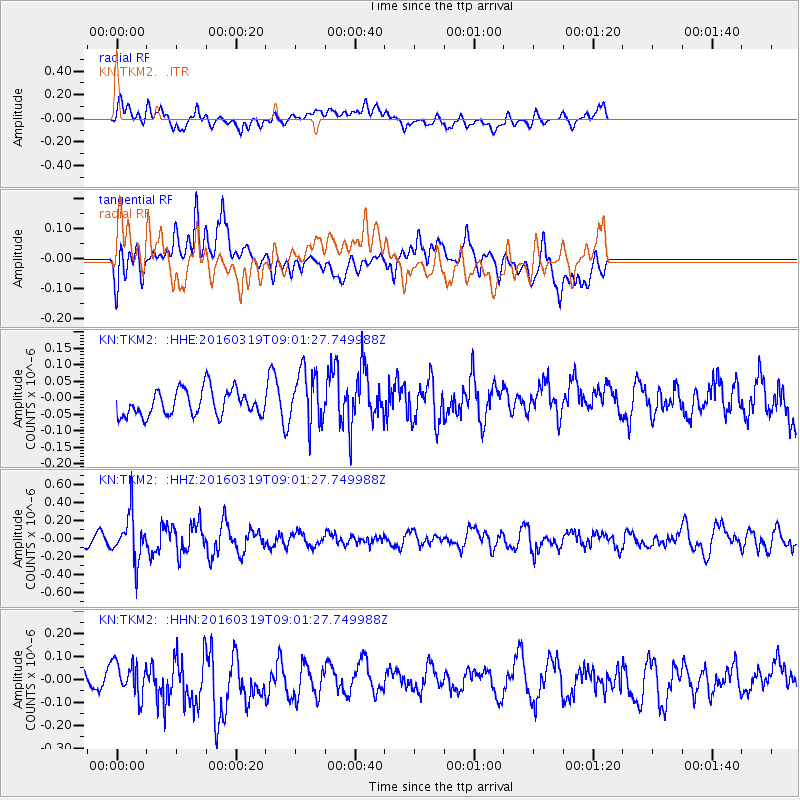
TKM2 - - Earthquake Result Viewer
*The percent match for this event was below the threshold and hence no stack was calculated.
| Earthquake location: |
Banda Sea |
| Earthquake latitude/longitude: |
-5.6/129.5 |
| Earthquake time(UTC): |
2016/03/19 (079) 08:51:24 GMT |
| Earthquake Depth: |
270 km |
| Earthquake Magnitude: |
5.7 MWW |
| Earthquake Catalog/Contributor: |
NEIC PDE/NEIC COMCAT |
|
| Network: |
KN Kyrgyz Seismic Telemetry Network |
| Station: |
TKM2 - |
| Lat/Lon: |
42.92 N/75.60 E |
| Elevation: |
2020 m |
|
| Distance: |
68.6 deg |
| Az: |
320.388 deg |
| Baz: |
120.241 deg |
| Ray Param: |
$rayparam |
*The percent match for this event was below the threshold and hence was not used in the summary stack. |
|
| Radial Match: |
53.117065 % |
| Radial Bump: |
400 |
| Transverse Match: |
47.422306 % |
| Transverse Bump: |
400 |
| SOD ConfigId: |
7422571 |
| Insert Time: |
2019-04-22 01:43:14.904 +0000 |
| GWidth: |
2.5 |
| Max Bumps: |
400 |
| Tol: |
0.001 |
|
Signal To Noise
| Channel | StoN | STA | LTA |
| KN:TKM2: :HHZ:20160319T09:01:27.749988Z | 3.794265 | 2.5159287E-7 | 6.630872E-8 |
| KN:TKM2: :HHN:20160319T09:01:27.749988Z | 1.5526903 | 7.2696054E-8 | 4.681942E-8 |
| KN:TKM2: :HHE:20160319T09:01:27.749988Z | 2.099682 | 8.270897E-8 | 3.9391185E-8 |
| Arrivals |
| Ps | |
| PpPs | |
| PsPs/PpSs | |


