You are here: Home > Network List > TA - USArray Transportable Network (new EarthScope stations) Stations List
> Station J01E Myrtle Point, OR, USA > Earthquake Result Viewer
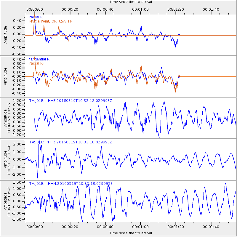
J01E Myrtle Point, OR, USA - Earthquake Result Viewer
*The percent match for this event was below the threshold and hence no stack was calculated.
| Earthquake location: |
Off Coast Of Central America |
| Earthquake latitude/longitude: |
11.9/-88.8 |
| Earthquake time(UTC): |
2016/03/19 (079) 10:24:45 GMT |
| Earthquake Depth: |
10 km |
| Earthquake Magnitude: |
5.6 MWC, 5.6 MWC, 5.6 MWW |
| Earthquake Catalog/Contributor: |
NEIC PDE/NEIC COMCAT |
|
| Network: |
TA USArray Transportable Network (new EarthScope stations) |
| Station: |
J01E Myrtle Point, OR, USA |
| Lat/Lon: |
43.16 N/123.93 W |
| Elevation: |
128 m |
|
| Distance: |
43.5 deg |
| Az: |
322.287 deg |
| Baz: |
125.079 deg |
| Ray Param: |
$rayparam |
*The percent match for this event was below the threshold and hence was not used in the summary stack. |
|
| Radial Match: |
72.60962 % |
| Radial Bump: |
400 |
| Transverse Match: |
63.240726 % |
| Transverse Bump: |
344 |
| SOD ConfigId: |
7422571 |
| Insert Time: |
2019-04-22 01:50:24.144 +0000 |
| GWidth: |
2.5 |
| Max Bumps: |
400 |
| Tol: |
0.001 |
|
Signal To Noise
| Channel | StoN | STA | LTA |
| TA:J01E: :HHZ:20160319T10:32:18.029993Z | 3.9019256 | 1.3173391E-6 | 3.3761253E-7 |
| TA:J01E: :HHN:20160319T10:32:18.029993Z | 0.8201569 | 2.856476E-7 | 3.482841E-7 |
| TA:J01E: :HHE:20160319T10:32:18.029993Z | 1.3072565 | 4.0258513E-7 | 3.0796187E-7 |
| Arrivals |
| Ps | |
| PpPs | |
| PsPs/PpSs | |


