You are here: Home > Network List > TA - USArray Transportable Network (new EarthScope stations) Stations List
> Station J20K Nowitna River, AK, USA > Earthquake Result Viewer
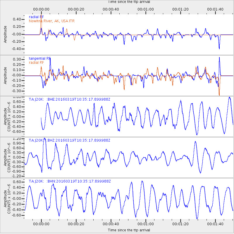
J20K Nowitna River, AK, USA - Earthquake Result Viewer
*The percent match for this event was below the threshold and hence no stack was calculated.
| Earthquake location: |
Off Coast Of Central America |
| Earthquake latitude/longitude: |
11.9/-88.8 |
| Earthquake time(UTC): |
2016/03/19 (079) 10:24:45 GMT |
| Earthquake Depth: |
10 km |
| Earthquake Magnitude: |
5.6 MWC, 5.6 MWC, 5.6 MWW |
| Earthquake Catalog/Contributor: |
NEIC PDE/NEIC COMCAT |
|
| Network: |
TA USArray Transportable Network (new EarthScope stations) |
| Station: |
J20K Nowitna River, AK, USA |
| Lat/Lon: |
64.18 N/154.15 W |
| Elevation: |
314 m |
|
| Distance: |
68.8 deg |
| Az: |
334.711 deg |
| Baz: |
107.296 deg |
| Ray Param: |
$rayparam |
*The percent match for this event was below the threshold and hence was not used in the summary stack. |
|
| Radial Match: |
59.585407 % |
| Radial Bump: |
346 |
| Transverse Match: |
74.381775 % |
| Transverse Bump: |
399 |
| SOD ConfigId: |
7422571 |
| Insert Time: |
2019-04-22 01:50:25.354 +0000 |
| GWidth: |
2.5 |
| Max Bumps: |
400 |
| Tol: |
0.001 |
|
Signal To Noise
| Channel | StoN | STA | LTA |
| TA:J20K: :BHZ:20160319T10:35:17.899988Z | 3.952106 | 7.755942E-7 | 1.9624832E-7 |
| TA:J20K: :BHN:20160319T10:35:17.899988Z | 0.8583022 | 2.5189425E-7 | 2.9347967E-7 |
| TA:J20K: :BHE:20160319T10:35:17.899988Z | 1.2683163 | 3.1453627E-7 | 2.4799513E-7 |
| Arrivals |
| Ps | |
| PpPs | |
| PsPs/PpSs | |


