You are here: Home > Network List > TA - USArray Transportable Network (new EarthScope stations) Stations List
> Station R11A Troy Canyon, Currant, NV, USA > Earthquake Result Viewer
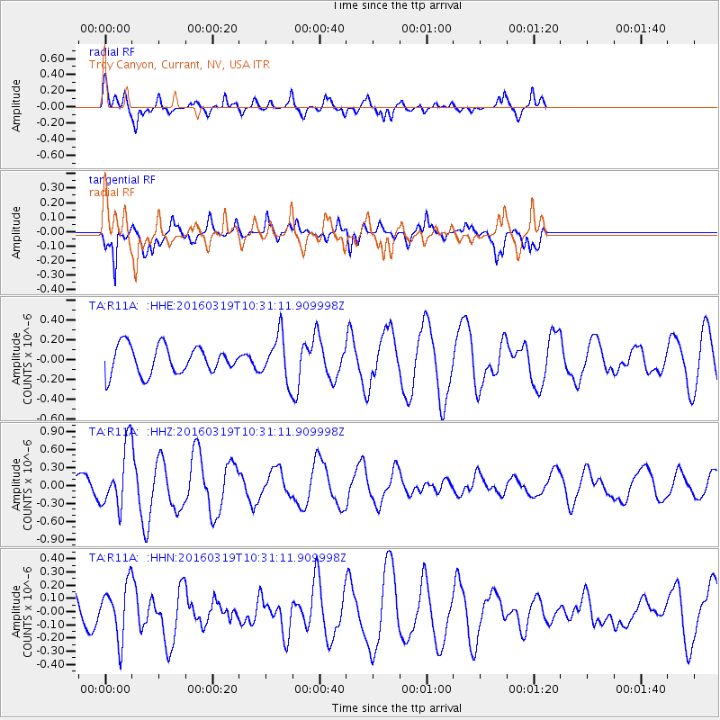
R11A Troy Canyon, Currant, NV, USA - Earthquake Result Viewer
*The percent match for this event was below the threshold and hence no stack was calculated.
| Earthquake location: |
Off Coast Of Central America |
| Earthquake latitude/longitude: |
11.9/-88.8 |
| Earthquake time(UTC): |
2016/03/19 (079) 10:24:45 GMT |
| Earthquake Depth: |
10 km |
| Earthquake Magnitude: |
5.6 MWC, 5.6 MWC, 5.6 MWW |
| Earthquake Catalog/Contributor: |
NEIC PDE/NEIC COMCAT |
|
| Network: |
TA USArray Transportable Network (new EarthScope stations) |
| Station: |
R11A Troy Canyon, Currant, NV, USA |
| Lat/Lon: |
38.35 N/115.59 W |
| Elevation: |
1756 m |
|
| Distance: |
35.6 deg |
| Az: |
322.449 deg |
| Baz: |
130.642 deg |
| Ray Param: |
$rayparam |
*The percent match for this event was below the threshold and hence was not used in the summary stack. |
|
| Radial Match: |
76.47051 % |
| Radial Bump: |
400 |
| Transverse Match: |
83.36048 % |
| Transverse Bump: |
341 |
| SOD ConfigId: |
7422571 |
| Insert Time: |
2019-04-22 01:50:42.741 +0000 |
| GWidth: |
2.5 |
| Max Bumps: |
400 |
| Tol: |
0.001 |
|
Signal To Noise
| Channel | StoN | STA | LTA |
| TA:R11A: :HHZ:20160319T10:31:11.909998Z | 3.345236 | 4.9957765E-7 | 1.4934002E-7 |
| TA:R11A: :HHN:20160319T10:31:11.909998Z | 1.3694186 | 2.0383582E-7 | 1.4884844E-7 |
| TA:R11A: :HHE:20160319T10:31:11.909998Z | 1.607223 | 2.271995E-7 | 1.4136153E-7 |
| Arrivals |
| Ps | |
| PpPs | |
| PsPs/PpSs | |


