You are here: Home > Network List > UW - Pacific Northwest Regional Seismic Network Stations List
> Station UMAT Pilot Rock, OR, USA > Earthquake Result Viewer
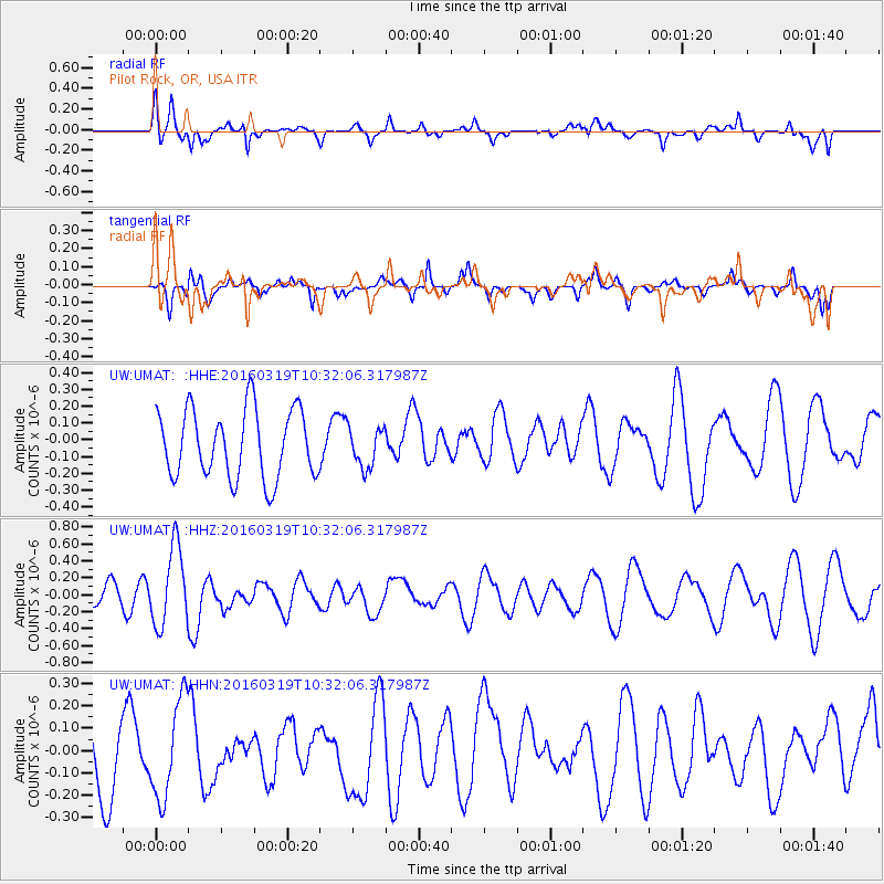
UMAT Pilot Rock, OR, USA - Earthquake Result Viewer
*The percent match for this event was below the threshold and hence no stack was calculated.
| Earthquake location: |
Off Coast Of Central America |
| Earthquake latitude/longitude: |
11.9/-88.8 |
| Earthquake time(UTC): |
2016/03/19 (079) 10:24:45 GMT |
| Earthquake Depth: |
10 km |
| Earthquake Magnitude: |
5.6 MWC, 5.6 MWC, 5.6 MWW |
| Earthquake Catalog/Contributor: |
NEIC PDE/NEIC COMCAT |
|
| Network: |
UW Pacific Northwest Regional Seismic Network |
| Station: |
UMAT Pilot Rock, OR, USA |
| Lat/Lon: |
45.29 N/118.96 W |
| Elevation: |
1318 m |
|
| Distance: |
42.1 deg |
| Az: |
328.025 deg |
| Baz: |
132.748 deg |
| Ray Param: |
$rayparam |
*The percent match for this event was below the threshold and hence was not used in the summary stack. |
|
| Radial Match: |
61.933613 % |
| Radial Bump: |
400 |
| Transverse Match: |
44.351067 % |
| Transverse Bump: |
333 |
| SOD ConfigId: |
7422571 |
| Insert Time: |
2019-04-22 01:51:09.223 +0000 |
| GWidth: |
2.5 |
| Max Bumps: |
400 |
| Tol: |
0.001 |
|
Signal To Noise
| Channel | StoN | STA | LTA |
| UW:UMAT: :HHZ:20160319T10:32:06.317987Z | 4.753065 | 4.5956338E-7 | 9.668779E-8 |
| UW:UMAT: :HHN:20160319T10:32:06.317987Z | 1.1112221 | 2.1850818E-7 | 1.9663771E-7 |
| UW:UMAT: :HHE:20160319T10:32:06.317987Z | 0.5762461 | 1.1676459E-7 | 2.0262974E-7 |
| Arrivals |
| Ps | |
| PpPs | |
| PsPs/PpSs | |


