You are here: Home > Network List > CI - Caltech Regional Seismic Network Stations List
> Station BAR Barrett, Tecate, CA, USA > Earthquake Result Viewer
BAR Barrett, Tecate, CA, USA - Earthquake Result Viewer
| Earthquake location: |
Andreanof Islands, Aleutian Is. |
| Earthquake latitude/longitude: |
51.6/-177.7 |
| Earthquake time(UTC): |
1999/03/20 (079) 10:47:45 GMT |
| Earthquake Depth: |
33 km |
| Earthquake Magnitude: |
6.3 MB, 6.8 MS, 6.9 MW, 6.8 ME |
| Earthquake Catalog/Contributor: |
WHDF/NEIC |
|
| Network: |
CI Caltech Regional Seismic Network |
| Station: |
BAR Barrett, Tecate, CA, USA |
| Lat/Lon: |
32.68 N/116.67 W |
| Elevation: |
521 m |
|
| Distance: |
47.5 deg |
| Az: |
88.781 deg |
| Baz: |
312.302 deg |
| Ray Param: |
0.0698604 |
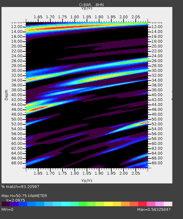
| Estimated Moho Depth: |
50.75 km |
| Estimated Crust Vp/Vs: |
2.10 |
| Assumed Crust Vp: |
6.264 km/s |
| Estimated Crust Vs: |
2.986 km/s |
| Estimated Crust Poisson's Ratio: |
0.35 |
|
| Radial Match: |
93.20597 % |
| Radial Bump: |
361 |
| Transverse Match: |
86.5516 % |
| Transverse Bump: |
400 |
| SOD ConfigId: |
3787 |
| Insert Time: |
2010-02-26 00:10:25.524 +0000 |
| GWidth: |
2.5 |
| Max Bumps: |
400 |
| Tol: |
0.001 |
|
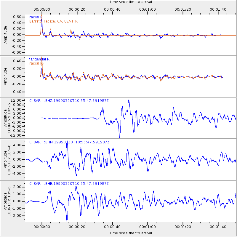
Signal To Noise
| Channel | StoN | STA | LTA |
| CI:BAR: :BHN:19990320T10:55:47.591987Z | 5.9287944 | 1.0527243E-6 | 1.7756128E-7 |
| CI:BAR: :BHE:19990320T10:55:47.591987Z | 5.6303887 | 6.885927E-7 | 1.2229931E-7 |
| CI:BAR: :BHZ:19990320T10:55:47.591987Z | 15.8407955 | 2.904007E-6 | 1.8332457E-7 |
| Arrivals |
| Ps | 9.3 SECOND |
| PpPs | 24 SECOND |
| PsPs/PpSs | 33 SECOND |


