You are here: Home > Network List > II - Global Seismograph Network (GSN - IRIS/IDA) Stations List
> Station PFO Pinon Flat, California, USA > Earthquake Result Viewer
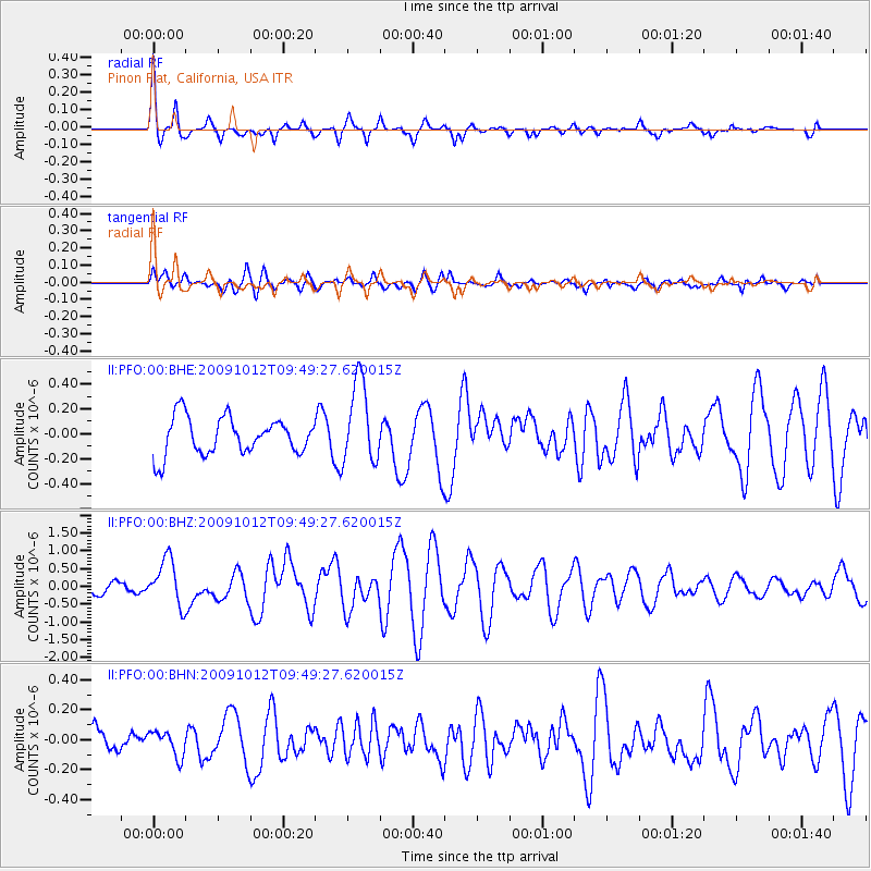
PFO Pinon Flat, California, USA - Earthquake Result Viewer
*The percent match for this event was below the threshold and hence no stack was calculated.
| Earthquake location: |
Santa Cruz Islands |
| Earthquake latitude/longitude: |
-12.4/166.5 |
| Earthquake time(UTC): |
2009/10/12 (285) 09:37:21 GMT |
| Earthquake Depth: |
42 km |
| Earthquake Magnitude: |
5.9 MB, 5.9 MS, 6.2 MW, 6.2 MW |
| Earthquake Catalog/Contributor: |
WHDF/NEIC |
|
| Network: |
II Global Seismograph Network (GSN - IRIS/IDA) |
| Station: |
PFO Pinon Flat, California, USA |
| Lat/Lon: |
33.61 N/116.46 W |
| Elevation: |
1280 m |
|
| Distance: |
86.3 deg |
| Az: |
54.589 deg |
| Baz: |
252.57 deg |
| Ray Param: |
$rayparam |
*The percent match for this event was below the threshold and hence was not used in the summary stack. |
|
| Radial Match: |
60.09894 % |
| Radial Bump: |
355 |
| Transverse Match: |
72.200615 % |
| Transverse Bump: |
400 |
| SOD ConfigId: |
1 |
| Insert Time: |
2010-02-19 00:42:52.837 +0000 |
| GWidth: |
2.5 |
| Max Bumps: |
400 |
| Tol: |
0.001 |
|
Signal To Noise
| Channel | StoN | STA | LTA |
| II:PFO:00:BHZ:20091012T09:49:27.620015Z | 4.883942 | 6.5602194E-7 | 1.343222E-7 |
| II:PFO:00:BHN:20091012T09:49:27.620015Z | 0.83659655 | 8.5070454E-8 | 1.01686354E-7 |
| II:PFO:00:BHE:20091012T09:49:27.620015Z | 2.2314625 | 3.312348E-7 | 1.4843843E-7 |
| Arrivals |
| Ps | |
| PpPs | |
| PsPs/PpSs | |


