You are here: Home > Network List > US - United States National Seismic Network Stations List
> Station HAWA Hanford, Washington, USA > Earthquake Result Viewer
HAWA Hanford, Washington, USA - Earthquake Result Viewer
*The percent match for this event was below the threshold and hence no stack was calculated.
| Earthquake location: |
North Atlantic Ocean |
| Earthquake latitude/longitude: |
13.9/-58.5 |
| Earthquake time(UTC): |
2015/07/16 (197) 15:16:32 GMT |
| Earthquake Depth: |
10 km |
| Earthquake Magnitude: |
6.5 MWW, 6.5 MWC, 6.5 MWB, 6.5 MI |
| Earthquake Catalog/Contributor: |
NEIC PDE/NEIC COMCAT |
|
| Network: |
US United States National Seismic Network |
| Station: |
HAWA Hanford, Washington, USA |
| Lat/Lon: |
46.39 N/119.53 W |
| Elevation: |
364 m |
|
| Distance: |
60.1 deg |
| Az: |
315.742 deg |
| Baz: |
101.665 deg |
| Ray Param: |
$rayparam |
*The percent match for this event was below the threshold and hence was not used in the summary stack. |
|
| Radial Match: |
70.905426 % |
| Radial Bump: |
400 |
| Transverse Match: |
63.42139 % |
| Transverse Bump: |
400 |
| SOD ConfigId: |
1085051 |
| Insert Time: |
2015-07-30 15:43:31.094 +0000 |
| GWidth: |
2.5 |
| Max Bumps: |
400 |
| Tol: |
0.001 |
|
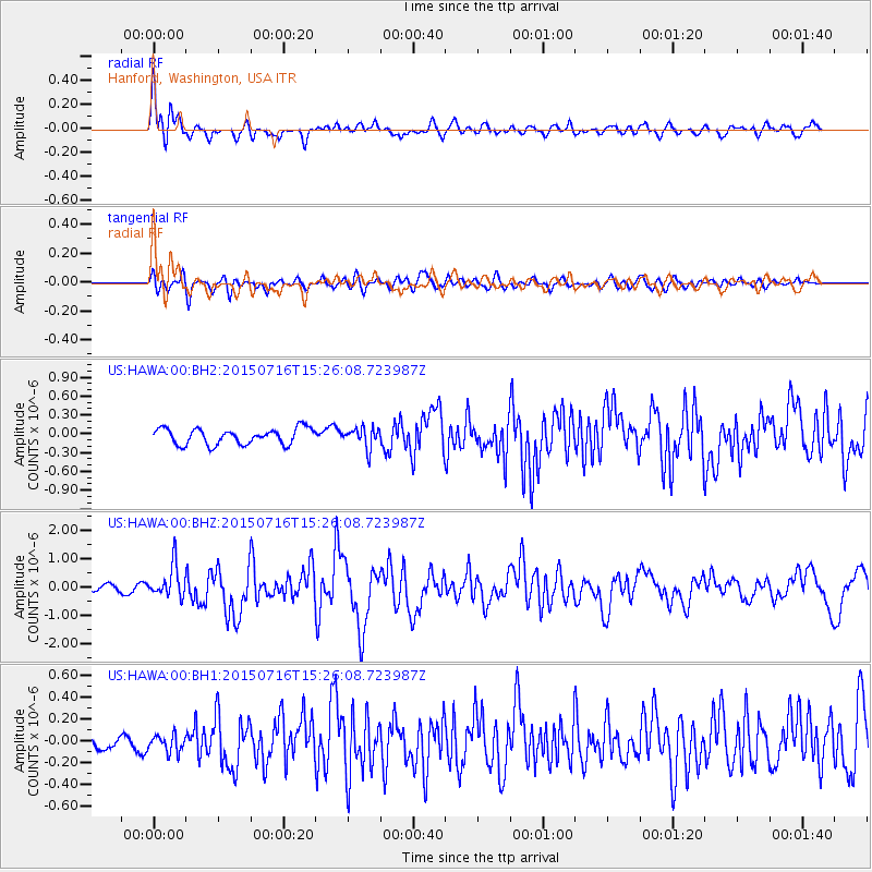
Signal To Noise
| Channel | StoN | STA | LTA |
| US:HAWA:00:BHZ:20150716T15:26:08.723987Z | 4.638625 | 5.6877815E-7 | 1.2261782E-7 |
| US:HAWA:00:BH1:20150716T15:26:08.723987Z | 0.9329011 | 7.843863E-8 | 8.4080334E-8 |
| US:HAWA:00:BH2:20150716T15:26:08.723987Z | 1.2704067 | 1.6112052E-7 | 1.2682592E-7 |
| Arrivals |
| Ps | |
| PpPs | |
| PsPs/PpSs | |


