You are here: Home > Network List > AZ - ANZA Regional Network Stations List
> Station SMER AZ.SMER > Earthquake Result Viewer
SMER AZ.SMER - Earthquake Result Viewer
*The percent match for this event was below the threshold and hence no stack was calculated.
| Earthquake location: |
Leeward Islands |
| Earthquake latitude/longitude: |
18.0/-60.7 |
| Earthquake time(UTC): |
2016/03/19 (079) 11:26:34 GMT |
| Earthquake Depth: |
32 km |
| Earthquake Magnitude: |
6.0 MWW, 5.9 MWB |
| Earthquake Catalog/Contributor: |
NEIC PDE/NEIC COMCAT |
|
| Network: |
AZ ANZA Regional Network |
| Station: |
SMER AZ.SMER |
| Lat/Lon: |
33.46 N/117.17 W |
| Elevation: |
355 m |
|
| Distance: |
52.6 deg |
| Az: |
298.634 deg |
| Baz: |
92.297 deg |
| Ray Param: |
$rayparam |
*The percent match for this event was below the threshold and hence was not used in the summary stack. |
|
| Radial Match: |
66.94097 % |
| Radial Bump: |
341 |
| Transverse Match: |
68.88563 % |
| Transverse Bump: |
359 |
| SOD ConfigId: |
7422571 |
| Insert Time: |
2019-04-22 01:53:58.137 +0000 |
| GWidth: |
2.5 |
| Max Bumps: |
400 |
| Tol: |
0.001 |
|
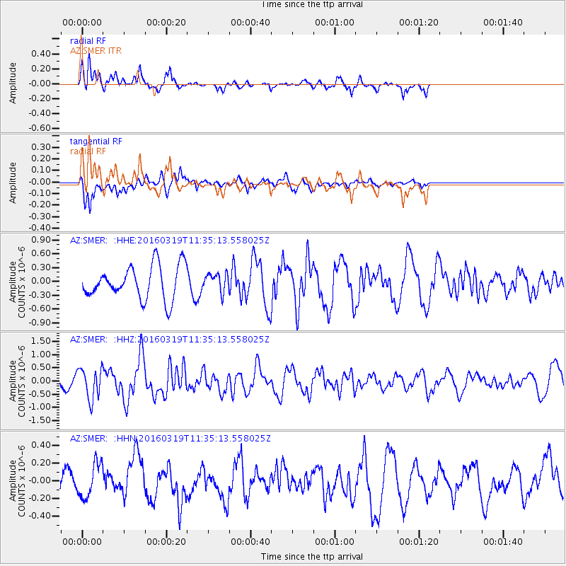
Signal To Noise
| Channel | StoN | STA | LTA |
| AZ:SMER: :HHZ:20160319T11:35:13.558025Z | 2.7403088 | 5.874235E-7 | 2.1436398E-7 |
| AZ:SMER: :HHN:20160319T11:35:13.558025Z | 1.8313272 | 1.9781992E-7 | 1.08019975E-7 |
| AZ:SMER: :HHE:20160319T11:35:13.558025Z | 0.57503676 | 2.0785416E-7 | 3.6146238E-7 |
| Arrivals |
| Ps | |
| PpPs | |
| PsPs/PpSs | |


