You are here: Home > Network List > CI - Caltech Regional Seismic Network Stations List
> Station SMM Simmler, CA, USA > Earthquake Result Viewer
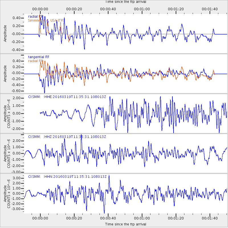
SMM Simmler, CA, USA - Earthquake Result Viewer
*The percent match for this event was below the threshold and hence no stack was calculated.
| Earthquake location: |
Leeward Islands |
| Earthquake latitude/longitude: |
18.0/-60.7 |
| Earthquake time(UTC): |
2016/03/19 (079) 11:26:34 GMT |
| Earthquake Depth: |
32 km |
| Earthquake Magnitude: |
6.0 MWW, 5.9 MWB |
| Earthquake Catalog/Contributor: |
NEIC PDE/NEIC COMCAT |
|
| Network: |
CI Caltech Regional Seismic Network |
| Station: |
SMM Simmler, CA, USA |
| Lat/Lon: |
35.31 N/120.00 W |
| Elevation: |
599 m |
|
| Distance: |
55.0 deg |
| Az: |
300.819 deg |
| Baz: |
92.001 deg |
| Ray Param: |
$rayparam |
*The percent match for this event was below the threshold and hence was not used in the summary stack. |
|
| Radial Match: |
71.21693 % |
| Radial Bump: |
400 |
| Transverse Match: |
46.208004 % |
| Transverse Bump: |
400 |
| SOD ConfigId: |
7422571 |
| Insert Time: |
2019-04-22 01:55:16.769 +0000 |
| GWidth: |
2.5 |
| Max Bumps: |
400 |
| Tol: |
0.001 |
|
Signal To Noise
| Channel | StoN | STA | LTA |
| CI:SMM: :HHZ:20160319T11:35:31.108013Z | 3.5414462 | 7.920107E-7 | 2.2364048E-7 |
| CI:SMM: :HHN:20160319T11:35:31.108013Z | 0.60625976 | 2.8131956E-7 | 4.640248E-7 |
| CI:SMM: :HHE:20160319T11:35:31.108013Z | 2.2938979 | 8.2382854E-7 | 3.591392E-7 |
| Arrivals |
| Ps | |
| PpPs | |
| PsPs/PpSs | |


