You are here: Home > Network List > CI - Caltech Regional Seismic Network Stations List
> Station SWS Sam W. Stewart, Westmorland, CA, USA > Earthquake Result Viewer
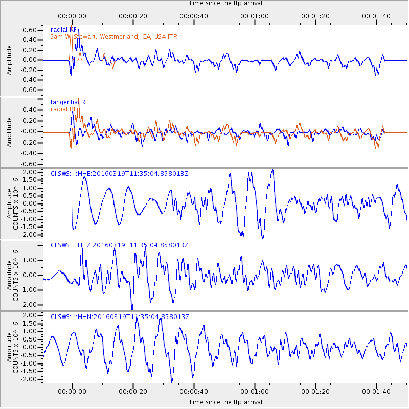
SWS Sam W. Stewart, Westmorland, CA, USA - Earthquake Result Viewer
*The percent match for this event was below the threshold and hence no stack was calculated.
| Earthquake location: |
Leeward Islands |
| Earthquake latitude/longitude: |
18.0/-60.7 |
| Earthquake time(UTC): |
2016/03/19 (079) 11:26:34 GMT |
| Earthquake Depth: |
32 km |
| Earthquake Magnitude: |
6.0 MWW, 5.9 MWB |
| Earthquake Catalog/Contributor: |
NEIC PDE/NEIC COMCAT |
|
| Network: |
CI Caltech Regional Seismic Network |
| Station: |
SWS Sam W. Stewart, Westmorland, CA, USA |
| Lat/Lon: |
32.94 N/115.80 W |
| Elevation: |
140 m |
|
| Distance: |
51.4 deg |
| Az: |
298.044 deg |
| Baz: |
92.683 deg |
| Ray Param: |
$rayparam |
*The percent match for this event was below the threshold and hence was not used in the summary stack. |
|
| Radial Match: |
67.19672 % |
| Radial Bump: |
400 |
| Transverse Match: |
67.01241 % |
| Transverse Bump: |
381 |
| SOD ConfigId: |
7422571 |
| Insert Time: |
2019-04-22 01:55:19.622 +0000 |
| GWidth: |
2.5 |
| Max Bumps: |
400 |
| Tol: |
0.001 |
|
Signal To Noise
| Channel | StoN | STA | LTA |
| CI:SWS: :HHZ:20160319T11:35:04.858013Z | 3.2667363 | 7.8001824E-7 | 2.38776E-7 |
| CI:SWS: :HHN:20160319T11:35:04.858013Z | 1.5598027 | 6.964456E-7 | 4.46496E-7 |
| CI:SWS: :HHE:20160319T11:35:04.858013Z | 0.60105485 | 5.294084E-7 | 8.8079884E-7 |
| Arrivals |
| Ps | |
| PpPs | |
| PsPs/PpSs | |


