You are here: Home > Network List > CI - Caltech Regional Seismic Network Stations List
> Station BAR Barrett, Tecate, CA, USA > Earthquake Result Viewer
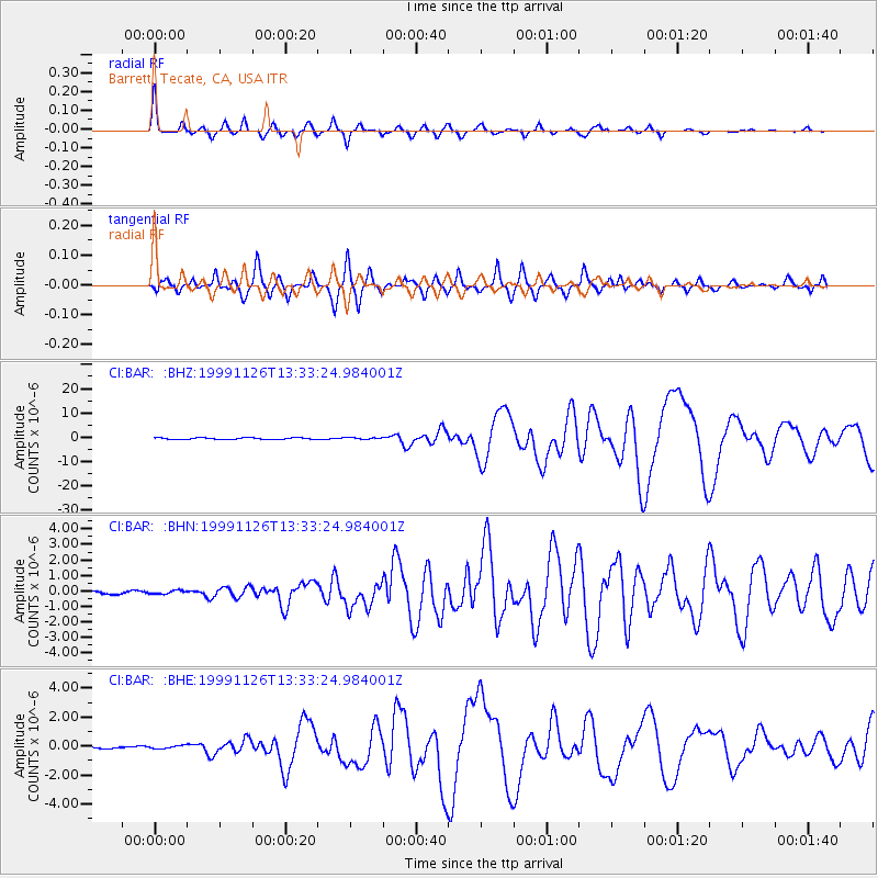
BAR Barrett, Tecate, CA, USA - Earthquake Result Viewer

| Earthquake location: |
Vanuatu Islands |
| Earthquake latitude/longitude: |
-16.4/168.2 |
| Earthquake time(UTC): |
1999/11/26 (330) 13:21:15 GMT |
| Earthquake Depth: |
33 km |
| Earthquake Magnitude: |
6.4 MB, 7.3 MS, 7.5 MW, 7.3 MW |
| Earthquake Catalog/Contributor: |
WHDF/NEIC |
|
| Network: |
CI Caltech Regional Seismic Network |
| Station: |
BAR Barrett, Tecate, CA, USA |
| Lat/Lon: |
32.68 N/116.67 W |
| Elevation: |
521 m |
|
| Distance: |
86.7 deg |
| Az: |
54.722 deg |
| Baz: |
248.281 deg |
| Ray Param: |
0.04379146 |
| Estimated Moho Depth: |
65.25 km |
| Estimated Crust Vp/Vs: |
1.70 |
| Assumed Crust Vp: |
6.264 km/s |
| Estimated Crust Vs: |
3.684 km/s |
| Estimated Crust Poisson's Ratio: |
0.24 |
|
| Radial Match: |
94.3777 % |
| Radial Bump: |
400 |
| Transverse Match: |
92.39828 % |
| Transverse Bump: |
400 |
| SOD ConfigId: |
3770 |
| Insert Time: |
2010-02-26 00:10:31.512 +0000 |
| GWidth: |
2.5 |
| Max Bumps: |
400 |
| Tol: |
0.001 |
|
Signal To Noise
| Channel | StoN | STA | LTA |
| CI:BAR: :BHN:19991126T13:33:24.984001Z | 0.63627774 | 1.1037736E-7 | 1.7347355E-7 |
| CI:BAR: :BHE:19991126T13:33:24.984001Z | 0.7579723 | 1.0907643E-7 | 1.4390557E-7 |
| CI:BAR: :BHZ:19991126T13:33:24.984001Z | 0.96016586 | 3.352564E-7 | 3.491651E-7 |
| Arrivals |
| Ps | 7.5 SECOND |
| PpPs | 27 SECOND |
| PsPs/PpSs | 35 SECOND |


