You are here: Home > Network List > N4 - Central and EAstern US Network Stations List
> Station L48A N Adams, MI, USA > Earthquake Result Viewer
L48A N Adams, MI, USA - Earthquake Result Viewer
| Earthquake location: |
Leeward Islands |
| Earthquake latitude/longitude: |
18.0/-60.7 |
| Earthquake time(UTC): |
2016/03/19 (079) 11:26:34 GMT |
| Earthquake Depth: |
32 km |
| Earthquake Magnitude: |
6.0 MWW, 5.9 MWB |
| Earthquake Catalog/Contributor: |
NEIC PDE/NEIC COMCAT |
|
| Network: |
N4 Central and EAstern US Network |
| Station: |
L48A N Adams, MI, USA |
| Lat/Lon: |
41.94 N/84.43 W |
| Elevation: |
369 m |
|
| Distance: |
31.3 deg |
| Az: |
324.702 deg |
| Baz: |
132.512 deg |
| Ray Param: |
0.07907418 |
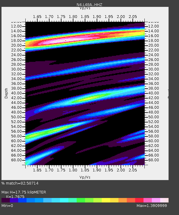
| Estimated Moho Depth: |
17.75 km |
| Estimated Crust Vp/Vs: |
1.77 |
| Assumed Crust Vp: |
6.498 km/s |
| Estimated Crust Vs: |
3.676 km/s |
| Estimated Crust Poisson's Ratio: |
0.26 |
|
| Radial Match: |
82.58714 % |
| Radial Bump: |
297 |
| Transverse Match: |
59.448383 % |
| Transverse Bump: |
400 |
| SOD ConfigId: |
7422571 |
| Insert Time: |
2019-04-22 01:57:23.190 +0000 |
| GWidth: |
2.5 |
| Max Bumps: |
400 |
| Tol: |
0.001 |
|

Signal To Noise
| Channel | StoN | STA | LTA |
| N4:L48A: :HHZ:20160319T11:32:20.669994Z | 5.6221013 | 1.1703306E-6 | 2.0816603E-7 |
| N4:L48A: :HHN:20160319T11:32:20.669994Z | 2.8809924 | 5.998495E-7 | 2.0820933E-7 |
| N4:L48A: :HHE:20160319T11:32:20.669994Z | 3.190023 | 6.4624703E-7 | 2.0258382E-7 |
| Arrivals |
| Ps | 2.3 SECOND |
| PpPs | 7.0 SECOND |
| PsPs/PpSs | 9.2 SECOND |


