You are here: Home > Network List > N4 - Central and EAstern US Network Stations List
> Station Y45B Coffeeville, MS, USA > Earthquake Result Viewer
Y45B Coffeeville, MS, USA - Earthquake Result Viewer
| Earthquake location: |
Leeward Islands |
| Earthquake latitude/longitude: |
18.0/-60.7 |
| Earthquake time(UTC): |
2016/03/19 (079) 11:26:34 GMT |
| Earthquake Depth: |
32 km |
| Earthquake Magnitude: |
6.0 MWW, 5.9 MWB |
| Earthquake Catalog/Contributor: |
NEIC PDE/NEIC COMCAT |
|
| Network: |
N4 Central and EAstern US Network |
| Station: |
Y45B Coffeeville, MS, USA |
| Lat/Lon: |
33.87 N/89.54 W |
| Elevation: |
101 m |
|
| Distance: |
30.2 deg |
| Az: |
307.15 deg |
| Baz: |
114.264 deg |
| Ray Param: |
0.07935478 |
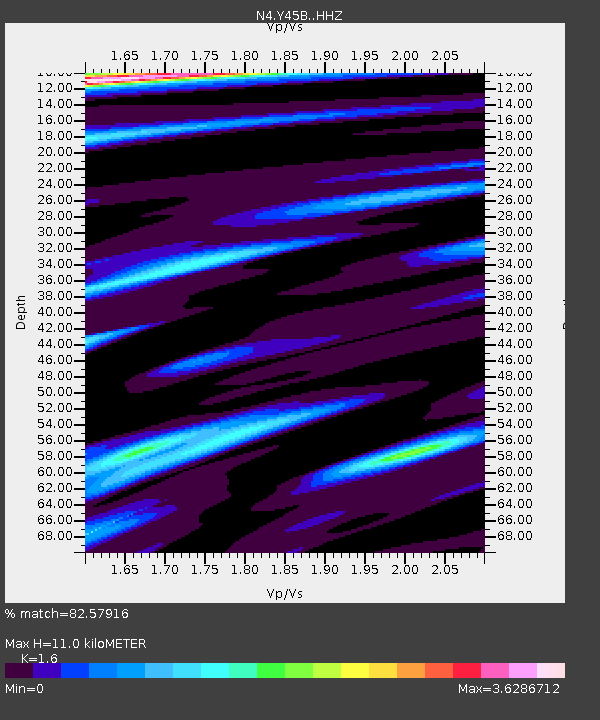
| Estimated Moho Depth: |
11.0 km |
| Estimated Crust Vp/Vs: |
1.60 |
| Assumed Crust Vp: |
6.201 km/s |
| Estimated Crust Vs: |
3.876 km/s |
| Estimated Crust Poisson's Ratio: |
0.18 |
|
| Radial Match: |
82.57916 % |
| Radial Bump: |
320 |
| Transverse Match: |
70.97795 % |
| Transverse Bump: |
380 |
| SOD ConfigId: |
7422571 |
| Insert Time: |
2019-04-22 01:57:40.054 +0000 |
| GWidth: |
2.5 |
| Max Bumps: |
400 |
| Tol: |
0.001 |
|

Signal To Noise
| Channel | StoN | STA | LTA |
| N4:Y45B: :HHZ:20160319T11:32:11.270Z | 8.2460985 | 1.7546311E-6 | 2.1278318E-7 |
| N4:Y45B: :HHN:20160319T11:32:11.270Z | 2.168934 | 9.0604306E-7 | 4.1773657E-7 |
| N4:Y45B: :HHE:20160319T11:32:11.270Z | 3.0370922 | 1.0877184E-6 | 3.5814466E-7 |
| Arrivals |
| Ps | 1.2 SECOND |
| PpPs | 4.2 SECOND |
| PsPs/PpSs | 5.4 SECOND |


