You are here: Home > Network List > TA - USArray Transportable Network (new EarthScope stations) Stations List
> Station 833A Chaparral WMA, Artesia Wells, TX, USA > Earthquake Result Viewer
833A Chaparral WMA, Artesia Wells, TX, USA - Earthquake Result Viewer

| Earthquake location: |
Leeward Islands |
| Earthquake latitude/longitude: |
18.0/-60.7 |
| Earthquake time(UTC): |
2016/03/19 (079) 11:26:34 GMT |
| Earthquake Depth: |
32 km |
| Earthquake Magnitude: |
6.0 MWW, 5.9 MWB |
| Earthquake Catalog/Contributor: |
NEIC PDE/NEIC COMCAT |
|
| Network: |
TA USArray Transportable Network (new EarthScope stations) |
| Station: |
833A Chaparral WMA, Artesia Wells, TX, USA |
| Lat/Lon: |
28.32 N/99.39 W |
| Elevation: |
171 m |
|
| Distance: |
36.9 deg |
| Az: |
293.352 deg |
| Baz: |
97.653 deg |
| Ray Param: |
0.07637453 |
| Estimated Moho Depth: |
30.75 km |
| Estimated Crust Vp/Vs: |
1.84 |
| Assumed Crust Vp: |
6.347 km/s |
| Estimated Crust Vs: |
3.449 km/s |
| Estimated Crust Poisson's Ratio: |
0.29 |
|
| Radial Match: |
86.921165 % |
| Radial Bump: |
382 |
| Transverse Match: |
41.892216 % |
| Transverse Bump: |
400 |
| SOD ConfigId: |
7422571 |
| Insert Time: |
2019-04-22 01:59:27.266 +0000 |
| GWidth: |
2.5 |
| Max Bumps: |
400 |
| Tol: |
0.001 |
|
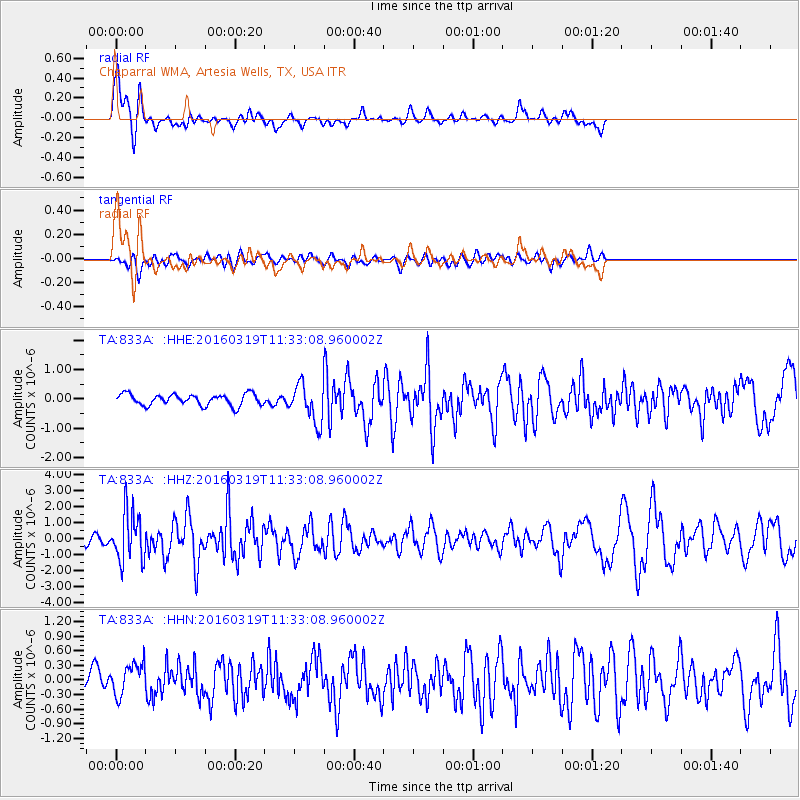
Signal To Noise
| Channel | StoN | STA | LTA |
| TA:833A: :HHZ:20160319T11:33:08.960002Z | 5.107296 | 1.5256553E-6 | 2.9872075E-7 |
| TA:833A: :HHN:20160319T11:33:08.960002Z | 1.4414177 | 3.2948776E-7 | 2.285859E-7 |
| TA:833A: :HHE:20160319T11:33:08.960002Z | 3.876459 | 7.4080333E-7 | 1.911031E-7 |
| Arrivals |
| Ps | 4.4 SECOND |
| PpPs | 13 SECOND |
| PsPs/PpSs | 17 SECOND |


