You are here: Home > Network List > TA - USArray Transportable Network (new EarthScope stations) Stations List
> Station G05D Wamic, OR, USA > Earthquake Result Viewer
G05D Wamic, OR, USA - Earthquake Result Viewer
*The percent match for this event was below the threshold and hence no stack was calculated.
| Earthquake location: |
Leeward Islands |
| Earthquake latitude/longitude: |
18.0/-60.7 |
| Earthquake time(UTC): |
2016/03/19 (079) 11:26:34 GMT |
| Earthquake Depth: |
32 km |
| Earthquake Magnitude: |
6.0 MWW, 5.9 MWB |
| Earthquake Catalog/Contributor: |
NEIC PDE/NEIC COMCAT |
|
| Network: |
TA USArray Transportable Network (new EarthScope stations) |
| Station: |
G05D Wamic, OR, USA |
| Lat/Lon: |
45.24 N/121.32 W |
| Elevation: |
592 m |
|
| Distance: |
56.8 deg |
| Az: |
312.653 deg |
| Baz: |
97.799 deg |
| Ray Param: |
$rayparam |
*The percent match for this event was below the threshold and hence was not used in the summary stack. |
|
| Radial Match: |
60.028 % |
| Radial Bump: |
379 |
| Transverse Match: |
62.903526 % |
| Transverse Bump: |
353 |
| SOD ConfigId: |
7422571 |
| Insert Time: |
2019-04-22 01:59:33.686 +0000 |
| GWidth: |
2.5 |
| Max Bumps: |
400 |
| Tol: |
0.001 |
|
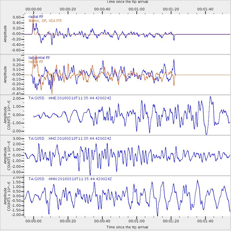
Signal To Noise
| Channel | StoN | STA | LTA |
| TA:G05D: :HHZ:20160319T11:35:44.420024Z | 3.861533 | 8.8763846E-7 | 2.2986687E-7 |
| TA:G05D: :HHN:20160319T11:35:44.420024Z | 0.58038706 | 2.6772753E-7 | 4.6129136E-7 |
| TA:G05D: :HHE:20160319T11:35:44.420024Z | 1.6218244 | 5.2860014E-7 | 3.2592934E-7 |
| Arrivals |
| Ps | |
| PpPs | |
| PsPs/PpSs | |


