You are here: Home > Network List > TA - USArray Transportable Network (new EarthScope stations) Stations List
> Station N23A Red Feather Lakes, CO, USA > Earthquake Result Viewer
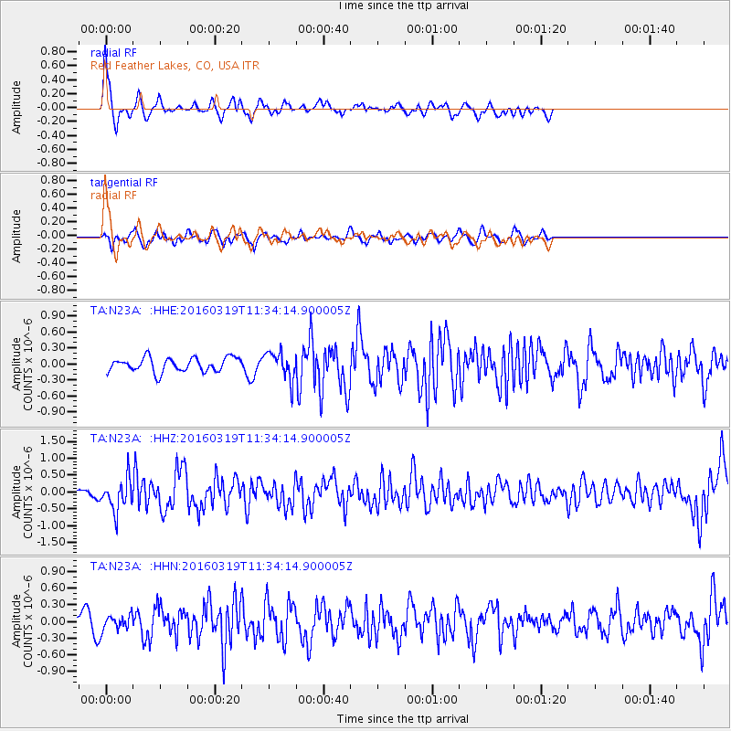
N23A Red Feather Lakes, CO, USA - Earthquake Result Viewer
*The percent match for this event was below the threshold and hence no stack was calculated.
| Earthquake location: |
Leeward Islands |
| Earthquake latitude/longitude: |
18.0/-60.7 |
| Earthquake time(UTC): |
2016/03/19 (079) 11:26:34 GMT |
| Earthquake Depth: |
32 km |
| Earthquake Magnitude: |
6.0 MWW, 5.9 MWB |
| Earthquake Catalog/Contributor: |
NEIC PDE/NEIC COMCAT |
|
| Network: |
TA USArray Transportable Network (new EarthScope stations) |
| Station: |
N23A Red Feather Lakes, CO, USA |
| Lat/Lon: |
40.89 N/105.94 W |
| Elevation: |
2458 m |
|
| Distance: |
44.9 deg |
| Az: |
310.317 deg |
| Baz: |
106.818 deg |
| Ray Param: |
$rayparam |
*The percent match for this event was below the threshold and hence was not used in the summary stack. |
|
| Radial Match: |
79.424225 % |
| Radial Bump: |
400 |
| Transverse Match: |
59.251606 % |
| Transverse Bump: |
400 |
| SOD ConfigId: |
7422571 |
| Insert Time: |
2019-04-22 01:59:47.342 +0000 |
| GWidth: |
2.5 |
| Max Bumps: |
400 |
| Tol: |
0.001 |
|
Signal To Noise
| Channel | StoN | STA | LTA |
| TA:N23A: :HHZ:20160319T11:34:14.900005Z | 2.749195 | 4.7074525E-7 | 1.712302E-7 |
| TA:N23A: :HHN:20160319T11:34:14.900005Z | 0.9116809 | 1.1948886E-7 | 1.3106435E-7 |
| TA:N23A: :HHE:20160319T11:34:14.900005Z | 2.0110676 | 2.6208454E-7 | 1.3032111E-7 |
| Arrivals |
| Ps | |
| PpPs | |
| PsPs/PpSs | |


