You are here: Home > Network List > TA - USArray Transportable Network (new EarthScope stations) Stations List
> Station X43A Marvell, AR, USA > Earthquake Result Viewer
X43A Marvell, AR, USA - Earthquake Result Viewer

| Earthquake location: |
Leeward Islands |
| Earthquake latitude/longitude: |
18.0/-60.7 |
| Earthquake time(UTC): |
2016/03/19 (079) 11:26:34 GMT |
| Earthquake Depth: |
32 km |
| Earthquake Magnitude: |
6.0 MWW, 5.9 MWB |
| Earthquake Catalog/Contributor: |
NEIC PDE/NEIC COMCAT |
|
| Network: |
TA USArray Transportable Network (new EarthScope stations) |
| Station: |
X43A Marvell, AR, USA |
| Lat/Lon: |
34.52 N/90.88 W |
| Elevation: |
53 m |
|
| Distance: |
31.5 deg |
| Az: |
307.429 deg |
| Baz: |
113.755 deg |
| Ray Param: |
0.078995824 |
| Estimated Moho Depth: |
31.0 km |
| Estimated Crust Vp/Vs: |
1.60 |
| Assumed Crust Vp: |
6.273 km/s |
| Estimated Crust Vs: |
3.915 km/s |
| Estimated Crust Poisson's Ratio: |
0.18 |
|
| Radial Match: |
99.18412 % |
| Radial Bump: |
75 |
| Transverse Match: |
92.27808 % |
| Transverse Bump: |
207 |
| SOD ConfigId: |
7422571 |
| Insert Time: |
2019-04-22 02:00:01.777 +0000 |
| GWidth: |
2.5 |
| Max Bumps: |
400 |
| Tol: |
0.001 |
|
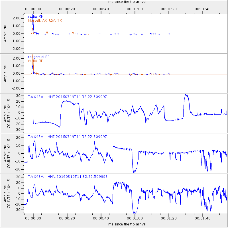
Signal To Noise
| Channel | StoN | STA | LTA |
| TA:X43A: :HHZ:20160319T11:32:22.50999Z | 0.63328475 | 7.252925E-6 | 1.1452866E-5 |
| TA:X43A: :HHN:20160319T11:32:22.50999Z | 0.36632 | 7.111965E-6 | 1.9414623E-5 |
| TA:X43A: :HHE:20160319T11:32:22.50999Z | 0.5176832 | 9.187363E-6 | 1.7747074E-5 |
| Arrivals |
| Ps | 3.2 SECOND |
| PpPs | 12 SECOND |
| PsPs/PpSs | 15 SECOND |


