You are here: Home > Network List > 7A - Mid-Atlantic Geophysical Integrative Collaboration Stations List
> Station PETO Lost Creek, West Virginia USA > Earthquake Result Viewer
PETO Lost Creek, West Virginia USA - Earthquake Result Viewer
| Earthquake location: |
Near East Coast Of Kamchatka |
| Earthquake latitude/longitude: |
54.3/162.8 |
| Earthquake time(UTC): |
2016/03/20 (080) 22:50:20 GMT |
| Earthquake Depth: |
31 km |
| Earthquake Magnitude: |
6.4 MWC, 6.2 MWB, 6.6 MI |
| Earthquake Catalog/Contributor: |
NEIC PDE/NEIC COMCAT |
|
| Network: |
7A Mid-Atlantic Geophysical Integrative Collaboration |
| Station: |
PETO Lost Creek, West Virginia USA |
| Lat/Lon: |
39.16 N/80.33 W |
| Elevation: |
0.0 m |
|
| Distance: |
72.3 deg |
| Az: |
46.715 deg |
| Baz: |
326.744 deg |
| Ray Param: |
0.053704754 |
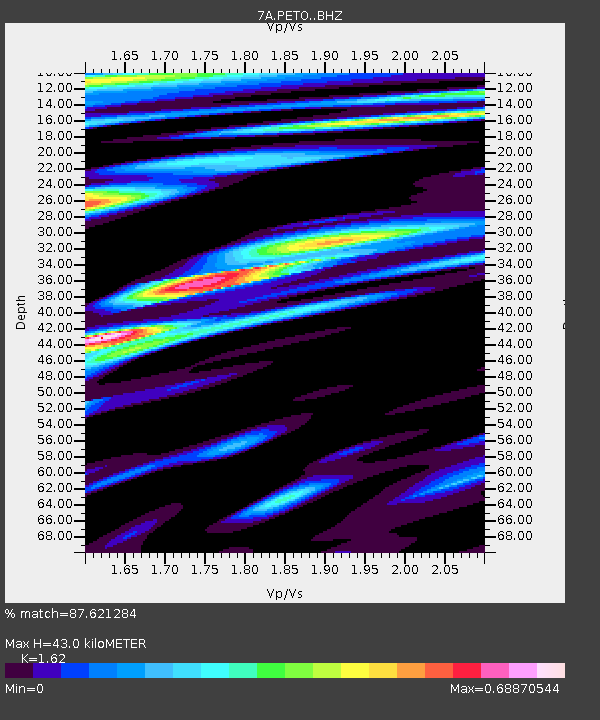
| Estimated Moho Depth: |
43.0 km |
| Estimated Crust Vp/Vs: |
1.62 |
| Assumed Crust Vp: |
6.207 km/s |
| Estimated Crust Vs: |
3.831 km/s |
| Estimated Crust Poisson's Ratio: |
0.19 |
|
| Radial Match: |
87.621284 % |
| Radial Bump: |
400 |
| Transverse Match: |
76.09827 % |
| Transverse Bump: |
400 |
| SOD ConfigId: |
7422571 |
| Insert Time: |
2019-04-22 02:02:34.160 +0000 |
| GWidth: |
2.5 |
| Max Bumps: |
400 |
| Tol: |
0.001 |
|

Signal To Noise
| Channel | StoN | STA | LTA |
| 7A:PETO: :BHZ:20160320T23:01:12.189971Z | 4.509054 | 1.0704546E-6 | 2.3740114E-7 |
| 7A:PETO: :BHN:20160320T23:01:12.189971Z | 1.8206095 | 4.021074E-7 | 2.2086417E-7 |
| 7A:PETO: :BHE:20160320T23:01:12.189971Z | 1.7525829 | 2.6368633E-7 | 1.5045583E-7 |
| Arrivals |
| Ps | 4.5 SECOND |
| PpPs | 18 SECOND |
| PsPs/PpSs | 22 SECOND |


