You are here: Home > Network List > CN - Canadian National Seismograph Network Stations List
> Station ATKO Atikokan Iron Mine, ON, CA > Earthquake Result Viewer
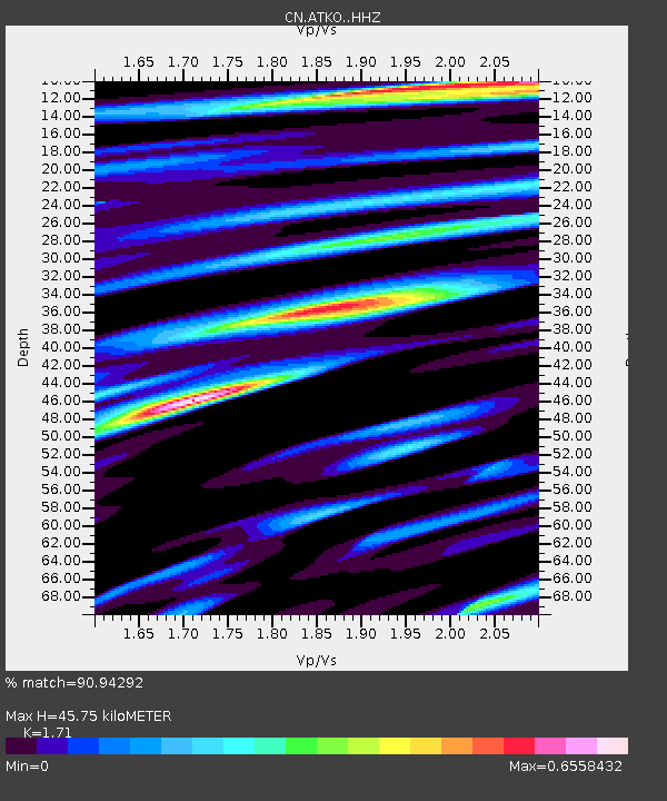
ATKO Atikokan Iron Mine, ON, CA - Earthquake Result Viewer
| Earthquake location: |
Near East Coast Of Kamchatka |
| Earthquake latitude/longitude: |
54.3/162.8 |
| Earthquake time(UTC): |
2016/03/20 (080) 22:50:20 GMT |
| Earthquake Depth: |
31 km |
| Earthquake Magnitude: |
6.4 MWC, 6.2 MWB, 6.6 MI |
| Earthquake Catalog/Contributor: |
NEIC PDE/NEIC COMCAT |
|
| Network: |
CN Canadian National Seismograph Network |
| Station: |
ATKO Atikokan Iron Mine, ON, CA |
| Lat/Lon: |
48.82 N/91.60 W |
| Elevation: |
383 m |
|
| Distance: |
59.7 deg |
| Az: |
47.485 deg |
| Baz: |
319.217 deg |
| Ray Param: |
0.06195016 |
| Estimated Moho Depth: |
45.75 km |
| Estimated Crust Vp/Vs: |
1.71 |
| Assumed Crust Vp: |
6.467 km/s |
| Estimated Crust Vs: |
3.782 km/s |
| Estimated Crust Poisson's Ratio: |
0.24 |
|
| Radial Match: |
90.94292 % |
| Radial Bump: |
381 |
| Transverse Match: |
70.22772 % |
| Transverse Bump: |
400 |
| SOD ConfigId: |
7422571 |
| Insert Time: |
2019-04-22 02:04:58.468 +0000 |
| GWidth: |
2.5 |
| Max Bumps: |
400 |
| Tol: |
0.001 |
|

Signal To Noise
| Channel | StoN | STA | LTA |
| CN:ATKO: :HHZ:20160320T22:59:51.540007Z | 3.7654936 | 8.765988E-7 | 2.3279785E-7 |
| CN:ATKO: :HHN:20160320T22:59:51.540007Z | 1.8105348 | 3.4743795E-7 | 1.9189797E-7 |
| CN:ATKO: :HHE:20160320T22:59:51.540007Z | 1.053983 | 2.583857E-7 | 2.4515168E-7 |
| Arrivals |
| Ps | 5.3 SECOND |
| PpPs | 18 SECOND |
| PsPs/PpSs | 24 SECOND |


