You are here: Home > Network List > HT - Aristotle University of Thessaloniki Seismological Network Stations List
> Station LIT Litochoro, Greece, HT-Net > Earthquake Result Viewer
LIT Litochoro, Greece, HT-Net - Earthquake Result Viewer
| Earthquake location: |
Near East Coast Of Kamchatka |
| Earthquake latitude/longitude: |
54.3/162.8 |
| Earthquake time(UTC): |
2016/03/20 (080) 22:50:20 GMT |
| Earthquake Depth: |
31 km |
| Earthquake Magnitude: |
6.4 MWC, 6.2 MWB, 6.6 MI |
| Earthquake Catalog/Contributor: |
NEIC PDE/NEIC COMCAT |
|
| Network: |
HT Aristotle University of Thessaloniki Seismological Network |
| Station: |
LIT Litochoro, Greece, HT-Net |
| Lat/Lon: |
40.10 N/22.49 E |
| Elevation: |
480 m |
|
| Distance: |
80.0 deg |
| Az: |
330.166 deg |
| Baz: |
22.325 deg |
| Ray Param: |
0.048563246 |
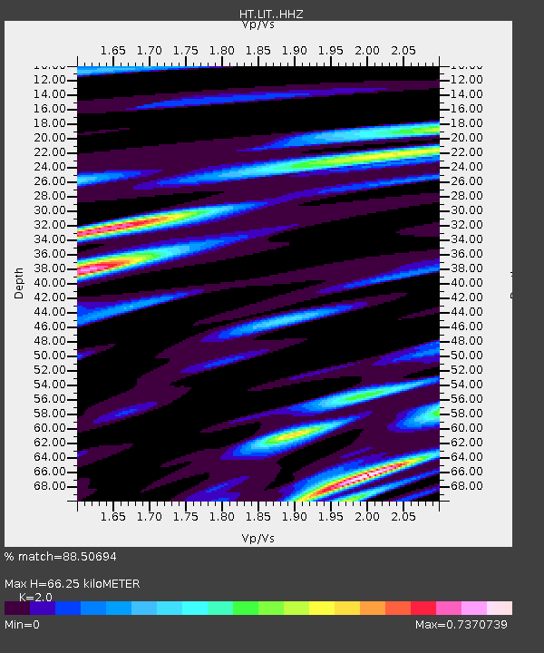
| Estimated Moho Depth: |
66.25 km |
| Estimated Crust Vp/Vs: |
2.00 |
| Assumed Crust Vp: |
6.279 km/s |
| Estimated Crust Vs: |
3.139 km/s |
| Estimated Crust Poisson's Ratio: |
0.33 |
|
| Radial Match: |
88.50694 % |
| Radial Bump: |
400 |
| Transverse Match: |
80.827415 % |
| Transverse Bump: |
400 |
| SOD ConfigId: |
7422571 |
| Insert Time: |
2019-04-22 02:06:29.253 +0000 |
| GWidth: |
2.5 |
| Max Bumps: |
400 |
| Tol: |
0.001 |
|

Signal To Noise
| Channel | StoN | STA | LTA |
| HT:LIT: :HHZ:20160320T23:01:55.649993Z | 31.820518 | 3.248052E-6 | 1.0207414E-7 |
| HT:LIT: :HHN:20160320T23:01:55.649993Z | 12.974838 | 1.1288952E-6 | 8.70065E-8 |
| HT:LIT: :HHE:20160320T23:01:55.649993Z | 4.670247 | 4.2198295E-7 | 9.03556E-8 |
| Arrivals |
| Ps | 11 SECOND |
| PpPs | 31 SECOND |
| PsPs/PpSs | 42 SECOND |


