You are here: Home > Network List > KP - Korea Polar Seismic Network Stations List
> Station UPNV Upernavik, Greenland > Earthquake Result Viewer
UPNV Upernavik, Greenland - Earthquake Result Viewer
| Earthquake location: |
Near East Coast Of Kamchatka |
| Earthquake latitude/longitude: |
54.3/162.8 |
| Earthquake time(UTC): |
2016/03/20 (080) 22:50:20 GMT |
| Earthquake Depth: |
31 km |
| Earthquake Magnitude: |
6.4 MWC, 6.2 MWB, 6.6 MI |
| Earthquake Catalog/Contributor: |
NEIC PDE/NEIC COMCAT |
|
| Network: |
KP Korea Polar Seismic Network |
| Station: |
UPNV Upernavik, Greenland |
| Lat/Lon: |
72.78 N/56.14 W |
| Elevation: |
38 m |
|
| Distance: |
50.3 deg |
| Az: |
14.069 deg |
| Baz: |
331.441 deg |
| Ray Param: |
0.0680572 |
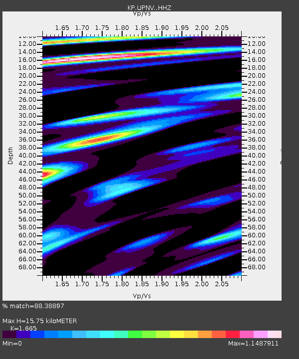
| Estimated Moho Depth: |
15.75 km |
| Estimated Crust Vp/Vs: |
1.66 |
| Assumed Crust Vp: |
6.307 km/s |
| Estimated Crust Vs: |
3.788 km/s |
| Estimated Crust Poisson's Ratio: |
0.22 |
|
| Radial Match: |
88.38897 % |
| Radial Bump: |
400 |
| Transverse Match: |
79.167145 % |
| Transverse Bump: |
400 |
| SOD ConfigId: |
7422571 |
| Insert Time: |
2019-04-22 02:07:17.481 +0000 |
| GWidth: |
2.5 |
| Max Bumps: |
400 |
| Tol: |
0.001 |
|

Signal To Noise
| Channel | StoN | STA | LTA |
| KP:UPNV: :HHZ:20160320T22:58:44.130004Z | 22.239258 | 3.0642138E-6 | 1.37784E-7 |
| KP:UPNV: :HHN:20160320T22:58:44.130004Z | 9.989615 | 1.2456968E-6 | 1.2469917E-7 |
| KP:UPNV: :HHE:20160320T22:58:44.130004Z | 7.904247 | 1.0053757E-6 | 1.2719437E-7 |
| Arrivals |
| Ps | 1.8 SECOND |
| PpPs | 6.3 SECOND |
| PsPs/PpSs | 8.0 SECOND |


