You are here: Home > Network List > N4 - Central and EAstern US Network Stations List
> Station F63A Nahmakanta, Browneville, ME, USA > Earthquake Result Viewer
F63A Nahmakanta, Browneville, ME, USA - Earthquake Result Viewer
| Earthquake location: |
Near East Coast Of Kamchatka |
| Earthquake latitude/longitude: |
54.3/162.8 |
| Earthquake time(UTC): |
2016/03/20 (080) 22:50:20 GMT |
| Earthquake Depth: |
31 km |
| Earthquake Magnitude: |
6.4 MWC, 6.2 MWB, 6.6 MI |
| Earthquake Catalog/Contributor: |
NEIC PDE/NEIC COMCAT |
|
| Network: |
N4 Central and EAstern US Network |
| Station: |
F63A Nahmakanta, Browneville, ME, USA |
| Lat/Lon: |
45.70 N/69.10 W |
| Elevation: |
386 m |
|
| Distance: |
71.0 deg |
| Az: |
35.671 deg |
| Baz: |
330.834 deg |
| Ray Param: |
0.054541666 |
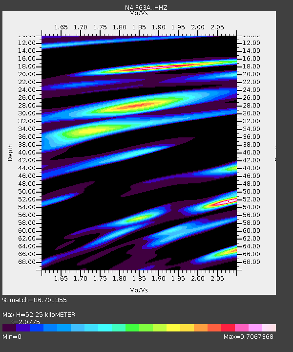
| Estimated Moho Depth: |
52.25 km |
| Estimated Crust Vp/Vs: |
2.08 |
| Assumed Crust Vp: |
6.419 km/s |
| Estimated Crust Vs: |
3.09 km/s |
| Estimated Crust Poisson's Ratio: |
0.35 |
|
| Radial Match: |
86.701355 % |
| Radial Bump: |
400 |
| Transverse Match: |
74.13481 % |
| Transverse Bump: |
400 |
| SOD ConfigId: |
7422571 |
| Insert Time: |
2019-04-22 02:08:22.832 +0000 |
| GWidth: |
2.5 |
| Max Bumps: |
400 |
| Tol: |
0.001 |
|

Signal To Noise
| Channel | StoN | STA | LTA |
| N4:F63A: :HHZ:20160320T23:01:04.600005Z | 3.217249 | 9.643145E-7 | 2.9973265E-7 |
| N4:F63A: :HHN:20160320T23:01:04.600005Z | 2.148146 | 3.87309E-7 | 1.8029921E-7 |
| N4:F63A: :HHE:20160320T23:01:04.600005Z | 1.71466 | 3.6881082E-7 | 2.1509268E-7 |
| Arrivals |
| Ps | 9.0 SECOND |
| PpPs | 24 SECOND |
| PsPs/PpSs | 33 SECOND |


