You are here: Home > Network List > N4 - Central and EAstern US Network Stations List
> Station W45B Hickory Valley, TN, USA > Earthquake Result Viewer
W45B Hickory Valley, TN, USA - Earthquake Result Viewer
| Earthquake location: |
Near East Coast Of Kamchatka |
| Earthquake latitude/longitude: |
54.3/162.8 |
| Earthquake time(UTC): |
2016/03/20 (080) 22:50:20 GMT |
| Earthquake Depth: |
31 km |
| Earthquake Magnitude: |
6.4 MWC, 6.2 MWB, 6.6 MI |
| Earthquake Catalog/Contributor: |
NEIC PDE/NEIC COMCAT |
|
| Network: |
N4 Central and EAstern US Network |
| Station: |
W45B Hickory Valley, TN, USA |
| Lat/Lon: |
35.16 N/89.19 W |
| Elevation: |
182 m |
|
| Distance: |
71.6 deg |
| Az: |
55.222 deg |
| Baz: |
324.05 deg |
| Ray Param: |
0.054197207 |
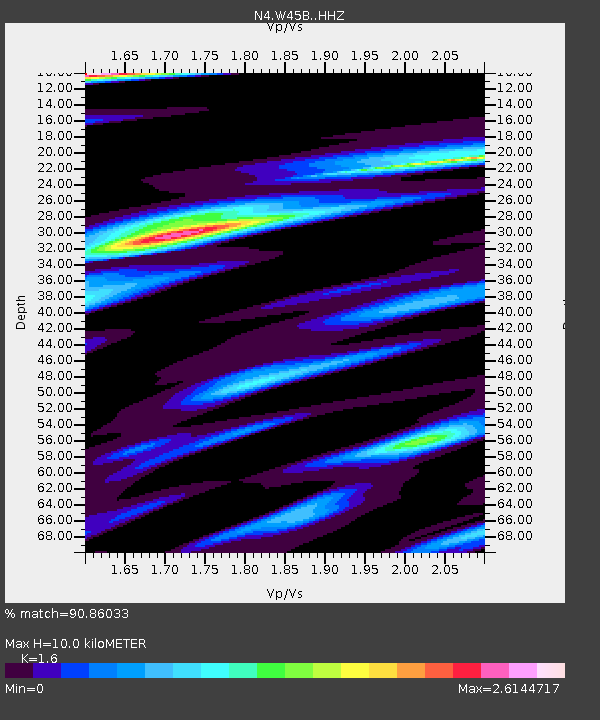
| Estimated Moho Depth: |
10.0 km |
| Estimated Crust Vp/Vs: |
1.60 |
| Assumed Crust Vp: |
6.38 km/s |
| Estimated Crust Vs: |
3.988 km/s |
| Estimated Crust Poisson's Ratio: |
0.18 |
|
| Radial Match: |
90.86033 % |
| Radial Bump: |
360 |
| Transverse Match: |
75.76675 % |
| Transverse Bump: |
400 |
| SOD ConfigId: |
7422571 |
| Insert Time: |
2019-04-22 02:09:40.799 +0000 |
| GWidth: |
2.5 |
| Max Bumps: |
400 |
| Tol: |
0.001 |
|

Signal To Noise
| Channel | StoN | STA | LTA |
| N4:W45B: :HHZ:20160320T23:01:07.73001Z | 5.524493 | 8.801676E-7 | 1.5932096E-7 |
| N4:W45B: :HHN:20160320T23:01:07.73001Z | 0.78058195 | 4.6616378E-7 | 5.972003E-7 |
| N4:W45B: :HHE:20160320T23:01:07.73001Z | 1.0279251 | 4.839447E-7 | 4.7079757E-7 |
| Arrivals |
| Ps | 1.0 SECOND |
| PpPs | 3.9 SECOND |
| PsPs/PpSs | 4.9 SECOND |


