You are here: Home > Network List > NN - Western Great Basin/Eastern Sierra Nevada Stations List
> Station EMB Emerald Bay, California w84 > Earthquake Result Viewer
EMB Emerald Bay, California w84 - Earthquake Result Viewer
| Earthquake location: |
Near East Coast Of Kamchatka |
| Earthquake latitude/longitude: |
54.3/162.8 |
| Earthquake time(UTC): |
2016/03/20 (080) 22:50:20 GMT |
| Earthquake Depth: |
31 km |
| Earthquake Magnitude: |
6.4 MWC, 6.2 MWB, 6.6 MI |
| Earthquake Catalog/Contributor: |
NEIC PDE/NEIC COMCAT |
|
| Network: |
NN Western Great Basin/Eastern Sierra Nevada |
| Station: |
EMB Emerald Bay, California w84 |
| Lat/Lon: |
38.97 N/120.10 W |
| Elevation: |
2134 m |
|
| Distance: |
52.4 deg |
| Az: |
73.449 deg |
| Baz: |
313.928 deg |
| Ray Param: |
0.06670625 |
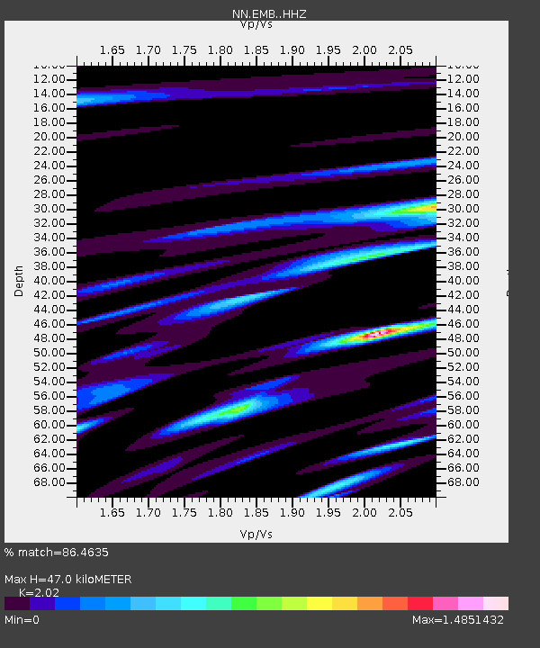
| Estimated Moho Depth: |
47.0 km |
| Estimated Crust Vp/Vs: |
2.02 |
| Assumed Crust Vp: |
6.597 km/s |
| Estimated Crust Vs: |
3.266 km/s |
| Estimated Crust Poisson's Ratio: |
0.34 |
|
| Radial Match: |
86.4635 % |
| Radial Bump: |
400 |
| Transverse Match: |
76.22418 % |
| Transverse Bump: |
400 |
| SOD ConfigId: |
7422571 |
| Insert Time: |
2019-04-22 02:10:06.796 +0000 |
| GWidth: |
2.5 |
| Max Bumps: |
400 |
| Tol: |
0.001 |
|

Signal To Noise
| Channel | StoN | STA | LTA |
| NN:EMB: :HHZ:20160320T22:58:59.457976Z | 3.5787227 | 9.107936E-7 | 2.545024E-7 |
| NN:EMB: :HHN:20160320T22:58:59.457976Z | 2.9524372 | 5.871997E-7 | 1.9888643E-7 |
| NN:EMB: :HHE:20160320T22:58:59.457976Z | 0.7494768 | 3.7037535E-7 | 4.9417855E-7 |
| Arrivals |
| Ps | 7.6 SECOND |
| PpPs | 20 SECOND |
| PsPs/PpSs | 28 SECOND |


