You are here: Home > Network List > NY - Yukon Northwest Seismic Network(YNSN) Stations List
> Station MMPY Sheldon Lake, Yukon, CANADA > Earthquake Result Viewer
MMPY Sheldon Lake, Yukon, CANADA - Earthquake Result Viewer
| Earthquake location: |
Near East Coast Of Kamchatka |
| Earthquake latitude/longitude: |
54.3/162.8 |
| Earthquake time(UTC): |
2016/03/20 (080) 22:50:20 GMT |
| Earthquake Depth: |
31 km |
| Earthquake Magnitude: |
6.4 MWC, 6.2 MWB, 6.6 MI |
| Earthquake Catalog/Contributor: |
NEIC PDE/NEIC COMCAT |
|
| Network: |
NY Yukon Northwest Seismic Network(YNSN) |
| Station: |
MMPY Sheldon Lake, Yukon, CANADA |
| Lat/Lon: |
62.62 N/131.26 W |
| Elevation: |
0.0 m |
|
| Distance: |
34.0 deg |
| Az: |
49.037 deg |
| Baz: |
286.954 deg |
| Ray Param: |
0.07790373 |
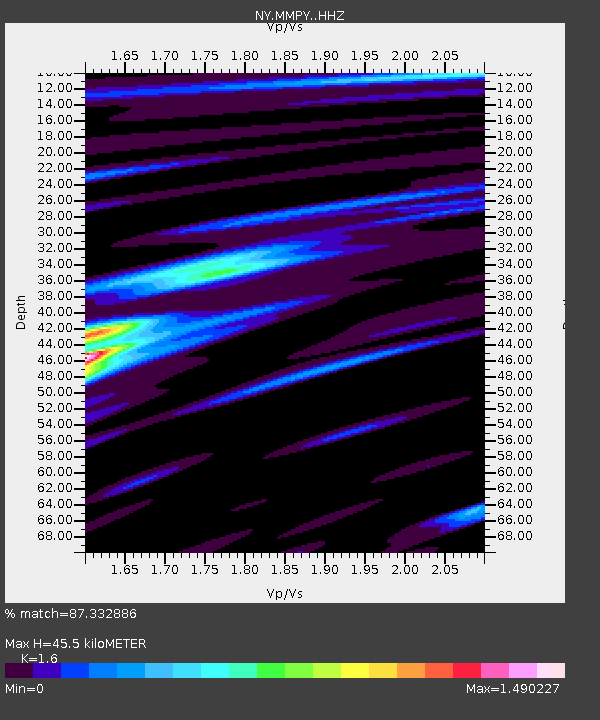
| Estimated Moho Depth: |
45.5 km |
| Estimated Crust Vp/Vs: |
1.60 |
| Assumed Crust Vp: |
6.419 km/s |
| Estimated Crust Vs: |
4.012 km/s |
| Estimated Crust Poisson's Ratio: |
0.18 |
|
| Radial Match: |
87.332886 % |
| Radial Bump: |
327 |
| Transverse Match: |
71.32197 % |
| Transverse Bump: |
400 |
| SOD ConfigId: |
7422571 |
| Insert Time: |
2019-04-22 02:10:45.780 +0000 |
| GWidth: |
2.5 |
| Max Bumps: |
400 |
| Tol: |
0.001 |
|

Signal To Noise
| Channel | StoN | STA | LTA |
| NY:MMPY: :HHZ:20160320T22:56:31.110015Z | 5.0403743 | 1.0495262E-6 | 2.0822385E-7 |
| NY:MMPY: :HHN:20160320T22:56:31.110015Z | 1.9545283 | 1.18591856E-7 | 6.067543E-8 |
| NY:MMPY: :HHE:20160320T22:56:31.110015Z | 5.3657446 | 6.3420083E-7 | 1.1819438E-7 |
| Arrivals |
| Ps | 4.6 SECOND |
| PpPs | 17 SECOND |
| PsPs/PpSs | 22 SECOND |


