You are here: Home > Network List > RV - Regional Alberta Seismic Observatory for Earthquake Studies Network Stations List
> Station STPRA Salt Prairie Lookout Tower, AB > Earthquake Result Viewer
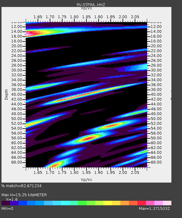
STPRA Salt Prairie Lookout Tower, AB - Earthquake Result Viewer
| Earthquake location: |
Near East Coast Of Kamchatka |
| Earthquake latitude/longitude: |
54.3/162.8 |
| Earthquake time(UTC): |
2016/03/20 (080) 22:50:20 GMT |
| Earthquake Depth: |
31 km |
| Earthquake Magnitude: |
6.4 MWC, 6.2 MWB, 6.6 MI |
| Earthquake Catalog/Contributor: |
NEIC PDE/NEIC COMCAT |
|
| Network: |
RV Regional Alberta Seismic Observatory for Earthquake Studies Network |
| Station: |
STPRA Salt Prairie Lookout Tower, AB |
| Lat/Lon: |
55.66 N/115.83 W |
| Elevation: |
761 m |
|
| Distance: |
44.1 deg |
| Az: |
53.563 deg |
| Baz: |
303.75 deg |
| Ray Param: |
0.07204159 |
| Estimated Moho Depth: |
15.25 km |
| Estimated Crust Vp/Vs: |
1.60 |
| Assumed Crust Vp: |
6.483 km/s |
| Estimated Crust Vs: |
4.052 km/s |
| Estimated Crust Poisson's Ratio: |
0.18 |
|
| Radial Match: |
92.671234 % |
| Radial Bump: |
400 |
| Transverse Match: |
77.43322 % |
| Transverse Bump: |
400 |
| SOD ConfigId: |
7422571 |
| Insert Time: |
2019-04-22 02:12:05.274 +0000 |
| GWidth: |
2.5 |
| Max Bumps: |
400 |
| Tol: |
0.001 |
|

Signal To Noise
| Channel | StoN | STA | LTA |
| RV:STPRA: :HHZ:20160320T22:57:55.70999Z | 5.7533345 | 1.0662205E-6 | 1.853222E-7 |
| RV:STPRA: :HHN:20160320T22:57:55.70999Z | 0.963159 | 3.9323183E-7 | 4.08273E-7 |
| RV:STPRA: :HHE:20160320T22:57:55.70999Z | 1.4749902 | 6.7606146E-7 | 4.5834977E-7 |
| Arrivals |
| Ps | 1.5 SECOND |
| PpPs | 5.7 SECOND |
| PsPs/PpSs | 7.2 SECOND |


